U.S. Route 97 in Washington
US 97 is a major highway in Washington that spans 322-mile (518.209 km) and consists of mostly two lanes;[1] it is undivided except for the sections that are in urban areas, such as Wenatchee, and concurrencies with I-82 and I-90.
[11][12] US 97 ascends from the Columbia River Gorge and turns north near a Stonehenge replica to intersect State Route 14 (SR 14),[13] a riverside highway between Vancouver and the Tri-Cities that US 97 briefly follows west in a concurrency.
[3][14] The highway leaves SR 14 and its spur route to continue northeast into the Columbia Hills by following Davies Pass, parallel to the historic Maryhill Loops Road.
[15][16] US 97 reaches a plateau at the top of the hills and heads north, passing the Windy Point/Windy Flats and Big Horn wind farms and skirting the east side of Goldendale, where it intersects SR 142.
[18][19] It then crosses the Simcoe Mountains at Satus Pass, 3,107 feet (947 m) above sea level,[14] and enters the Yakama Indian Reservation.
[3] US 97 descends from the mountains by following Satus Creek northeast through the semi-arid steppe hills of southern Yakima County.
The freeway turns northeast and continues around Selah, intersecting SR 821 at the south end of the Yakima Canyon Highway.
It then descends into the Kittitas Valley, intersecting SR 821 again and turning north to reach the terminus of I-82 at an interchange with I-90 southeast of Ellensburg.
The concurrency ends in the western outskirts of Ellensburg, as US 97 briefly uses a section of University Way before turning north at a roundabout.
[12] US 97 continues along a ridge with wind turbines and quarries at the edge of the Kittitas Valley and intersects SR 970 at Virden before entering the Wenatchee National Forest.
[21] It then follows Swauk Creek as it ascends into the Wenatchee Mountains (part of the Cascade Range), passing several trailheads, campgrounds, and the former townsite of Liberty.
[3][22] The highway turns east to reach Blewett Pass, its highest point at 4,102 feet (1,250 m) above sea level, and crosses into Chelan County.
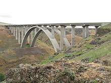
North of the city, US 2/US 97 passes through interchanges with SR 285, the main connector into downtown Wenatchee, and US 97 Alternate (US 97A) as it turns east to cross the Columbia River on the Richard Odabashian Bridge.
[3] US 2/US 97 enters Douglas County and turns north at a junction with SR 28, which continues through East Wenatchee towards Quincy.
The highway continues north and east along the Columbia River, passing Daroga State Park and several apple orchards on the edge of the Waterville Plateau.
US 97 continues north, passing the Wells Dam at Azwell, and enters Okanogan County near Alta Lake State Park.
The highway continues northeast along the river to Brewster, where it intersects SR 173 before turning east towards Anderson Field.
[3] US 97 and SR 20 form a concurrency as they bypass Okanogan and serve the county fairgrounds and 12 Tribes Omak Casino.
The highway also bypasses Omak, intersecting SR 155 via its spur route, and crosses the Okanogan River to leave the Colville Indian Reservation.
The highway continues northeast to rejoin the river, following its west bank until the town of Riverside, where it splits to use Wagonroad Coulee.
[24] The Inland Empire Highway was established in 1915 and the section it overlapped with present-day US 97 ran from Buena northwest to Ellensburg.
[50] Beginning in 2006, the Washington State Department of Transportation (WSDOT) has completed five construction projects on the US 97 corridor, ranging from a bridge deck replacement in Maryhill to repaving the roadway between Oroville area and Canada.
[57][58] Between August 11 and December 5, 2008, WSDOT added sidewalks and illumination along a 0.59-mile (0.95 km) long stretch of the highway between Main Street and SR 173 in Brewster.
[30] In late 2006, a replacement project was planned and the estimated $16 million USD cost was split between the governments of Washington and Oregon.
[84][85] On July 27, WSDOT will start to fix an unstable slope north of Blewett Pass, 8 miles (13 km) south of the US 2 intersection.
[1] The highway begins at a partial cloverleaf interchange with US 97 / US 2 north of Wenatchee and west of the Richard Odabashian Bridge over the Columbia River.