U.S. Route 9 in New York
In New York, US 9 extends 324.72 miles (522.59 km) from the George Washington Bridge in Manhattan to an interchange with Interstate 87 (I-87) just south of the Canadian border in the town of Champlain.
It is known as Broadway in Upper Manhattan, the Bronx and much of Westchester County,[3] and uses parts of the old Albany Post Road in the Hudson Valley, where it passes the historic homes of a U.S. President (Franklin D. Roosevelt) and Gilded Age heir.
[14] Near the island's northern tip, at the intersection with 215th Street, the elevated IRT Broadway–Seventh Avenue Line (1 train) of the New York City Subway joins Broadway.
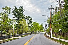
After intersecting with Ashford Avenue, US 9 passes Mercy College, then turns left again at the center of town just past South Presbyterian Church, headed for equally comfortable Irvington.
The road then enters Sleepy Hollow (formerly North Tarrytown), passing the visitors' center for Kykuit, the NHL that was (and partially still is) the Rockefeller family's estate.
[21] The expressway veers inland for much of its route, preferring to follow the railroad tracks (the new Cortlandt station is visible to the west at one point), rather than the river past the promontory at Buchanan.
At the Interstate exit, the road expands into a four-lane strip similar to the form it takes in Central New Jersey, complete with much commercial development on both sides.
[10] Just north of I-84, US 9 clips off a corner of the village of Fishkill, where the intersection with NY 52 creates a heavily congested situation at rush hours since traffic going from southbound US 9 to westbound I-84 often uses it as a shortcut.
This creates some unusual left exits, as traffic from US 44/NY 55 east wanting to go north on US 9 is routed into a U-turn south of the highway, and, likewise, northbound drivers on US 9 must get turned around to go west over the river.
[10] North of Poughkeepsie, US 9 is at first a busy four-lane undivided route, with occasional turn lanes as it approaches Hyde Park, passing Marist College, the main campus of the Culinary Institute of America and then the home and presidential library of native Franklin D. Roosevelt.
North of Red Hook, the land around the road begins to open up into farms and fields, offering frequent views of the Catskill Escarpment across the river.
US 9 turns northward again toward Hudson, the county seat, 1.5 miles (2.4 km) west, in Greenport, passing the Holcim-owned cement plant whose expansion was recently blocked by community activists after seven contentious years.
[10] As the roadway heads westward, it meets the western (southern for state purposes) terminus of US 4 across from a Hannaford Brothers Company supermarket along the busy commercial strip in East Greenbush.
At a bluff east of the river, the entire Albany skyline comes into view as the road descends, passing the northern terminus of NY 9J south of Rensselaer.
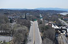
US 9 and US 20 then cross the Hudson River via the Dunn Memorial Bridge into Albany as Corning Tower and the other buildings of the Empire State Plaza loom ahead, and the two routes separate, with US 20 heading west across the city.
US 9 turns north on Henry Johnson Boulevard and widens to cross I-90 again via a flyover originally built for the canceled Mid-Crosstown Arterial, exiting the city of Albany in the process.
[10] Just before reaching the northern suburb of Colonie, US 9 returns to two lanes and follows Loudon Road through well-to-do residential neighborhoods past Albany Memorial Hospital and Wolferts Roost Country Club.
The roads continue running parallel courses past Round Lake as NY 67 joins US 9 into Malta, leaving 1.6 miles (2.6 km) later at the center of town for its own exit along the Northway.
From the hamlet of Kings Station onward, what is now signed as Saratoga Road follows a straight northeast course for 10 miles (16 km) through more wooded countryside to the entrance to Moreau Lake State Park.
US 9 continues straight ahead for the next three miles (4.8 km) into the village of South Glens Falls, where NY 32 (Gansevoort Road) comes in at an oblique angle from the south and merges with US 9 to cross the Hudson via the Cooper's Cave Bridge for the last time, leaving Saratoga County and entering the Warren County city of Glens Falls.
The next 90 miles (140 km) of the highway runs through the eastern section of the largest protected area east of the Mississippi River, 6,100,000 acres (2,500,000 ha) with vast tracts of Forest Preserve kept "forever wild" per the state constitution.
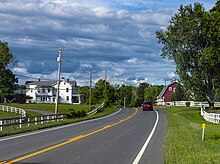
Development, traffic, and population are minimal, the surrounding land is heavily wooded, and the two roads cover very long distances between very small towns.
[10] US 9 remains close to the interstate for the next 16 miles (26 km) into the town of North Hudson, where Boreas Road provides access to the Dix Mountain Wilderness Area the southernmost in the Adirondack High Peaks region.
The highway again crosses the interstate to connect I-87 to the western terminus of NY 73, the well-traveled scenic route to Keene Valley and Lake Placid.
[10] While the land remains mostly forested as the road continues its northeast course from Elizabethtown, it begins to descend somewhat as the valley of Lake Champlain draws near.
At the Dead Creek crossing, US 9 widens to four lanes for the first time since the Albany area to handle the heavy traffic at the junction with the eastern terminus of NY 314, which continues east on County Route 57 (CR 57) to another ferry connector, just southeast of the Northway.
[10] US 9 runs straight due north, no longer taking another name, three miles (4.8 km) to the next major intersection, NY 9B (Lavalley Road), its last subroute.
[10] US 9 winds through the quiet border village as its Main Street, turning west-northwest near Champlain's northern boundary to make its last water crossing over the Chazy River.
The route, still known as Main Street, heads northwest toward the Northway to follow it for the last 0.5 miles (0.80 km), passing a few customs brokerages toward its official end at the on-ramp to the last exit.
[33] In the original 1925 plan for the U.S. Numbered Highway System, US 9 was designated along the west bank of the Hudson River from the New Jersey line to Albany, utilizing then-NY 10.