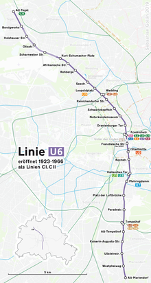
U6 (Berlin U-Bahn)
After Mehringplatz at the Hallesches Tor station, U6 crosses under the Landwehr Canal and swings slightly westwards to run parallel to Mehringdamm, which changes its name to Tempelhofer Damm at the Platz der Luftbrücke station, and then to Mariendorfer Damm after crossing the Teltow Canal.
This work was delayed and finally abandoned due to difficulties associated with World War I. Relics of this early phase up to 1918 can still be found in the rolled-steel support pillars at the Oranienburger Tor station, still bearing the trade name of the supplying rolling mill, Rombach in Alsace-Lorraine.
The result is that passengers transferring between the two lines still today have to walk through a long connecting pedestrian tunnel, popularly known by Berliners as the “mouse route” ("Mäusetunnel").
Work on the other branch only began in 1924, but just two years later, on 14 February 1926, the stretch from Belle-Alliance-Straße to Kreuzberg (now the Platz der Luftbrücke station) was opened.
Since the station had to be built very deep to accommodate the subway line, there was room for a spacious ticket hall.
This extension from the existing Seestraße station to the center of Tegel made several bus and tram lines redundant and for that reason this stretch was the first to be worked on after the war in the western part of the city.
The 6.9 km (4.3 mi) stretch was built in two sections: For reasons of cost and because of a very high water table there, north of Kurt-Schumacher-Platz it was decided to put the track on an embankment instead of in a cutting.
As was the case before World War II, the stations had a very functional design with its surfaces covered with bright, pastel-colored ceramic tiles.
At that station, West-Berlin passengers could transfer to the S-Bahn or enter East Berlin via the established border crossing there.
To service the area formerly accessible to the East Berlin population via the U6, until the ghost stations were reopened a bus line 59 was established between the Walter Ulbricht-Stadium, later renamed World Youth Stadium (Stadion der Weltjugend), and Leipziger Straße.
As with the northern extension to Tegel, ever since construction of Line C began it was planned to extend it to Alt-Mariendorf as the southern terminus.
When work on the long-awaited extension began, there were debates about the cost and it was, for example, proposed to lay the track in a cutting next to the Tempelhofer Damm/Mariendorf Damm roads.
Similar to the construction of today’s U7 line to Rudow, the canal posed the biggest problem for the track in this area and an unusual solution was found.
The U6 tracks are contained in a construction underneath and connected to the lower part of the road traffic bridge over the canal.
As with the southern part of the U7 line, he used large rectangular ceramic tiles to surface the station walls.
When the U6 was built between 1912 and 1923, money was scarce because of World War I and the subsequent hyperinflation period, and the tight budgetary situation of the city of Berlin as the owner of the new North-South line did not leave much of a financial margin.
The southern U6 extension goes from Alt-Mariendorf, Trabrennbahn Mariendorf, Tauernallee, Marienfelde Süd, Goethestraße, Barnetstraße and towards Alt-Lichtenrade.
For a feasibility study from 2020, a possible branch route to today's Berlin-Tegel airport or the future technology location Urban Tech Republic was examined.