Uinta County, Wyoming
[3] Uinta County was created on December 1, 1869, by the legislature of the Wyoming Territory, with its temporary seat located at Fort Bridger.
[4][5] Originally, it ran along the entire western border of Wyoming, including Yellowstone National Park.
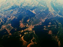
The 161 km wide western North American Fold and thrust belt extends from Alaska to Mexico, forming several northerly trending thrust faults in southwest Wyoming, including the Crawford, Absaroka and Hogsback (Darby), which formed from the Late Jurassic through the early Eocene.
The Painter Reservoir Field[9] was discovered in 1977 from the 407 m thick Nuggest Sandstone which forms an anticline structural trap in the hanging wall of the Absaroka thrust plate, at a depth of about 3 km.
20.90% of all households were made up of individuals, and 5.60% had someone living alone who was 65 years of age or older.
As of the 2010 United States Census, there were 21,118 people, 7,668 households, and 5,577 families in the county.
[18] In terms of ancestry, 33.4% were English, 23.0% were German, 12.0% were Irish, 6.5% were Scottish, 5.1% were Scotch-Irish, and 3.3% were American.
[21] Religion in Uinta County, according to ARDA (2020) [1] A majority of residents describe themselves as Christian, with the Church of Jesus Christ of Latter-day Saints claiming slightly less than half the population as of 2020.
[24] Researchers argue that most of the "Nones" should be considered "unchurched", rather than objectively nonreligious;[23][25][26][27][28] especially since most "Nones" do hold some religious-spiritual beliefs and a notable amount participate in behaviors.
[34] The facility was operated by the Wyoming Board of Charities and Reform until that agency was dissolved as a result of a state constitutional amendment passed in November 1990.