Ulithi
Falalop is the most accessible with Ulithi Airport, a small resort hotel, store and one of three public high schools in Yap state.
[3] The Spanish navigator Álvaro de Saavedra arrived on the ship Florida on 1 January 1528, claiming the islands for King Philip II under the name Islands of the Kings (Spanish: Islas de los Reyes; French: Îles des Rois) after his patron and the Three Wise Men honored in the approaching Catholic feast of Epiphany.
[8] However, the Spanish made similar claims and later that year Pope Leo XIII decreed Spain as the ruling power over the islands, granting Germany and the United Kingdom trading rights.
[9][10] In 1889, a significant earthquake hit Yap (and Ulithi),[11] leading the residents to believe that their engagement with outsiders had angered their traditional spirits.
SMS Planet was dispatched by the Germans to Ulithi for emergency food and relief, and eventually evacuated 114 residents to Yap.
[15] Under the Japanese occupation, businessmen and soldiers eroded the traditional political system in Ulithi, with the authority of local chiefs ignored.
[16] The presence of the Catholic church was reinforced by the Japanese, who allowed the continued efforts of conversion to go on, further eroding the indigenous culture.
[11] Early in the Second World War, the Japanese had established a radio and weather station on Ulithi and had occasionally used the lagoon as an anchorage, but had abandoned it by 1944.
[20] On 23 September 1944, a regiment of the United States Army's 81st Division landed unopposed, followed a few days later by a battalion of Seabees.
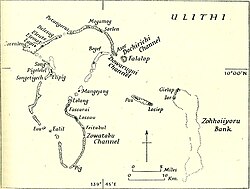
[21] The survey ship USS Sumner examined the lagoon and reported it capable of holding 700 vessels—a capacity greater than either Majuro or Pearl Harbor.
[23] Its commanding officer, Commodore Worrall R. Carter, devised the mobile service force that made it possible for the Navy to convert Ulithi to the secret distant Pacific base used during the major naval operations undertaken late in the war, including Leyte Gulf and the invasion of Okinawa.
Pontoon piers of a new design were built at Ulithi, each consisting of the 4-by-12-pontoon sections, filled with sand and gravel, and then sunk.
[23] Fleet oilers sortied from Ulithi to meet the task forces at sea, refueling the warships a short distance from their combat operational areas.
The result was something never seen before: a vast floating service station enabling the entire Pacific fleet to operate indefinitely at unprecedented distances from its mainland bases.
After the war Japanese naval officers said that two tender submarines, each carrying four manned torpedoes, had been sent to attack the fleet at Ulithi.
2, several long range aircraft flying from southern Japan attempted a nighttime kamikaze attack on the naval base.
The plane struck over the stern starboard quarter, damaging the flight deck and killing a number of crewmen.
The war had moved on, but for seven months in late 1944 and early 1945, the large lagoon of the Ulithi atoll was the largest and most active anchorage in the world.
[20] The LORAN (long-range navigation) station established on Potangeras during the naval occupation on the island continued to be operated by the United States Coast Guard post-war.
According to an August 1950 "HQ Party Inspection" memo, the move was predicated on the distance between Falalop and Potangeras, requiring a "four hour DUKW [amphibious transport] ride...".
Native handicraft is limited to canoe models, small statutes and grass skirts, which seldom run more than five or six dollars.
The weather and climate are close to ideal, the station and equipment are in excellent repair, recreational facilities are many and varied, supplies and mail are better than average, and the natives are interesting, sincere honest people.
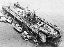
While the personnel was engaged in this activity, the winds picked up so noticeably that the local commanding officer notified the Coast Guard section on Guam it was going to move...equipment, personal gear, and emergency rations to a concrete bunker.As a major staging area for the United States Navy in the final year of the Second World War, several sunken warships rest at the bottom of the Ulithi lagoon, including USS Mississinewa, a fleet oiler which sank fully loaded.
Between January and February 2003, the Navy and subcontractors successfully emptied the fuel and oil, with 99% that remained in the wreckage removed.
[38] Census records can be misleading because population can fluctuate during the year because it is common for Ulithians to leave for work or school abroad and to return.
This is particularly true during festive times like the Outer Island High School graduation ceremony, when the population can increase considerably.
Since 2018, the Island Conservation[42] group has led an effort with the local community to help stop invasive species from overtaking native green sea turtles and seabirds.
[43] One of the non-native species they are attempting to eradicate is the monitor lizard, first introduced during the Japanese occupation to rid the islands of rats.
[44] Located on Falalop Island, the Ulithi Civil Airfield (IATA code ULI, FAA Identifier TT02) serves as the main air link with the rest of Federated States of Micronesia.
[35] In an annual report released in early 2010, the Habele charity announced plans to develop and distribute native-language materials for educators and students in the outer islands of Yap State, Micronesia.