Typhoon Ophelia
Typhoon Ophelia was a long-lived and powerful tropical cyclone that had devastating impacts on the small atoll of Ulithi in the Caroline Islands.
Moving slowly west-southwest, it steadily intensified into a tropical storm later that day and further into a typhoon on November 29 as it gained a steady westward track.
Passing Japan well to the southeast that day, its large circulation brought increased winds to the Tokyo area and heavy rain and snow to parts of the nation.
In addition to the severe impact in Ulithi, the typhoon was blamed for the deaths of five fishermen when their vessel collided with a coral reef.
On November 21, 1960, the formation of a small low-pressure area was noted following a shift in surface winds on Kwajalein Atoll in the Marshall Islands.
Initially, Ophelia was forecast to turn northward and impact the Mariana Islands but it ultimately followed a "sinusoidal pattern" path west.
By 0800 UTC on November 29, a 24 km (15 mi) wide eye formed over the storm's center and its central pressure had fallen to 982 mbar (hPa; 29.00 inHg), as measured by a United States Navy weather reconnaissance aircraft.
Sustained winds there reached 230 km/h (140 mph) while a barometer measured a minimum atmospheric pressure of 939.4 mbar (hPa; 27.744 inHg).
[1] The typhoon attained winds of 250 km/h (160 mph) while situated roughly halfway between the Philippines and the Mariana Islands at 0600 UTC on December 1.
[2] around 0600 UTC on December 2, reconnaissance measured a pressure of 928 mb (hPa; 27.41 inHg) within the now 40 km (25 mi) wide eye of Ophelia.
[1] The Japan Meteorological Agency estimated the pressure to have been slightly lower, reporting a minimum of 925 mb (hPa; 27.32 inHg).
[1] On November 30, Guam residents were given the all-clear after previously expecting potential impacts from the typhoon, as the storm remained south of the island.
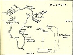
[12] On December 1, the eye of Typhoon Ophelia passed directly over the small atoll of Ulithi,[1] which has a total land area of 4.6 km2 (1.8 sq mi).
[14] At the time of the storm, an estimated 450 people lived on the island and 16 members of the United States Coast Guard were stationed there.
By this time, winds had already begun increasing and the commanding officer ordered that all equipment, personal gear, and emergency rations were to be taken into a concrete shelter.
[17] A Trust Territory vessel, the MV Errol, was anchored in the lagoon but left without warning nearby natives on November 29.
[15] Winds estimated at 260 km/h (160 mph) battered Ulithi, reportedly destroying every structure except for the concrete coast guard station.
[19] An anemometer on the coast guard station measured a peak velocity of 137 km/h (85 mph); however, later analysis of the device revealed that it was broken and revolving slower than it should.
[20] Along the south shore, two children were killed when their home collapsed, pinning them underneath debris, and water later inundated the area and drowned them.
[20] Mogmog Island, located at the northern end of the atoll's lagoon, saw the deposition of large boulders and cobblestone along its north shore which covered an area 30 to 45 m (98 to 148 ft) wide.
Unexpectedly, only a handful of people reported symptoms of posttraumatic stress disorder, with the majority seemingly unfazed by Ophelia.
[24] There was some talk among residents of leaving Ulithi and moving to nearby islands such as Yap, Palau, Saipan, or even the Philippines; however, mentions of this diminished relatively quickly.
Women, previously limited to agriculture, housework, and eventually shopping, were found to be doing heavy work (i.e. carpentry, chopping, digging, and lifting) in the immediate wake of the typhoon.

Tropical storm (39–73 mph, 63–118 km/h)
Category 1 (74–95 mph, 119–153 km/h)
Category 2 (96–110 mph, 154–177 km/h)
Category 3 (111–129 mph, 178–208 km/h)
Category 4 (130–156 mph, 209–251 km/h)
Category 5 (≥157 mph, ≥252 km/h)
Unknown