Underwater archaeology
[3] This changed when universities began teaching the subject and a theoretical and practical base for the sub-discipline was firmly established in the late 1980s.
[7][8] At the end of the last ice age, the North Sea was a great plain, and anthropological material, as well as the remains of animals such as mammoths, are sometimes recovered by trawlers.
As a result, underwater archaeological sites cover a vast range including: submerged indigenous sites and places where people once lived or visited that have been subsequently covered by water due to rising sea levels; wells, cenotes, wrecks (shipwrecks; aircraft); the remains of structures created in water (such as crannogs, bridges or harbors); other port-related structures; refuse or debris sites where people disposed of their waste, garbage and other items, such as ships, aircraft, munitions and machinery, by dumping into the water.
One is the wreck of the VOC ship Zuytdorp lost in 1711 on the coast of Western Australia, where there remains considerable speculation that some of the crew survived and, after establishing themselves on shore, intermixed with indigenous tribes from the area.
[10] The archaeological signature at this site also now extends into the interaction between indigenous people and the European pastoralists who entered the area in the mid-19th century.
For a marine site, while some form of working platform (typically a boat or ship) is often needed, shore-based activities are common.
A working platform for underwater archaeology needs to be equipped to provide for the delivery of air for example, recompression and medical facilities, or specialist remote sensing equipment, analysis of archaeological results, support for activities being undertaken in the water, storage of supplies, facilities for conservation for any items recovered from the water, as well as accommodation for workers.
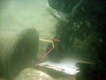
Equipment used for archaeological investigation, including water dredge and airlifts create additional hazards and logistics issues.
In addition, underwater sites can be chemically active, with the result that iron can be leached from metal structures to form concretions.
An example is the excavation of the Queen Anne's Revenge[26] and the QAR DiveLive program,[27] a live interactive virtual field trip to the wrecksite.
Although specialized techniques and tools have been developed to address the challenges of working under water, the archaeological goals and process are essentially the same as in any other context.
The depth of water over the site, and whether access is constrained by tides, currents and adverse weather conditions will create substantial constraints on the techniques that can feasibly be used and the amount of investigation that can be carried out for a given cost or in a set timescale.
Many of the most carefully investigated sites, including the Mary Rose have relied substantially on avocational archaeologists working over a considerable period of time.
[29] Where it is not practical or safe for divers to physically visit a site, Remotely Operated Vehicles (ROVs) enable observation and intervention with control by personnel located at the surface.
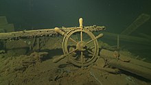
The "Mardi Gras Shipwreck" sank some 200 years ago about 35 miles off the coast of Louisiana in the Gulf of Mexico in 4,000 feet (1,200 meters) of water.
Photography and videography are the mainstays of recording, which has become much more convenient with the advent of reasonably priced digital still and HD video cameras.
Low visibility underwater and distortion of image due to refraction mean that perspective photographs can be difficult to obtain.
It may also provide additional information, including the area where the timber was harvested (i.e. likely to be where the ship was built) and whether or not there are later repairs or reuse of salvaged materials.
For example, for submerged terrestrial sites or inland water, identification of pollen samples from sedimentary or silt layers can provide information on the plants growing on surrounding land and hence on the nature of the landscape.
Television programs, web videos and social media can also bring an understanding of underwater archaeology to a broad audience.
For one week in 2000 and 2001, live underwater video of the Queen Anne's Revenge Shipwreck Project was webcast to the Internet as a part of the QAR DiveLive[27] educational program that reached thousands of children around the world.
[46] Created and co-produced by Nautilus Productions and Marine Grafics, this project enabled students to talk to scientists and learn about methods and technologies utilized by the underwater archaeology team.
[50] The public interest market is covered by a number of diving, shipwreck and underwater archaeology books, beginning with the works of Jacques Cousteau.