Unkar Group
The Unkar Group is a sequence of strata of Proterozoic age that are subdivided into five geologic formations and exposed within the Grand Canyon, Arizona, Southwestern United States.
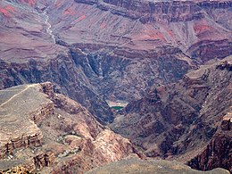
This can be seen at the Palisades fault in the eastern part of the main Unkar Group outcrop area (below East Rim).
Within the central Grand Canyon, Unkar strata occur in small, rotated, downfaulted blocks or slivers where they commonly are only partially exposed.
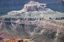
Examples of these fault blocks can be seen at the Isis Temple prominence, "Cheops Pyramid," and the intersection of Phantom Creek with the Bright Angel Canyon, (North Kaibab Trail).
First, the Unkar Group, as the bottom unit of the Grand Canyon Supergroup, lies directly upon deeply eroded granites, gneisses, pegmatites, and schists that comprise Vishnu Basement Rocks.
In 1910 and 1914, Levi F. Noble later divided what he called the "Unkar Group" into five subunits, which were the Hotauta Conglomerate, Bass Limestone, Hakatai Shale, Shinumo Quartzite, and Dox Sandstone.
In 1938, Charles R. Keyes applied the name "Cardenesan Series" to the basaltic volcanic rocks within the Unkar Group.
A prominent conglomerate, the Hotauta Member, fills paleovalleys cut into the underlying Vishu basement complex at its base.
The brightly colored slopes of the Hakatai Shale contrasts sharply against the grayish outcrops of the Bass Formation.
The sloping exposures of the Hakatai Shale also contrast greatly with the steep cliffs formed by the overlying Shinumo Quartzite.
The missing part of the Dox Formation and overlying Cardenas Basalt and Chuar Group can be found in a prominent syncline and fault block in the eastern Grand Canyon.
The lower part of this formation consists of complexly interbedded, thin, and discontinuous beds of basalt, hyaloclastite, and sandstone that form low, talus-covered slopes.
Angular unconformities of vastly differing magnitudes separate the Cardenas Basalt from the overlying Nankoweap Formation and Tonto Group.
They consist of black, medium- to coarse-grained, olivine-rich basalt that contains plagioclase, olivine, clinopyroxene, magnetite-ilmenite, and biotite.
Where it has not been removed by erosion prior to and during the deposition of the overlying Bass Formation, a residual regolith – developed by subaerial weathering of the underlying basement rocks – is present.
Typically, this regolith consists of dark-reddish brown, structureless, ferruginous sediment that is usually a few centimeters to 30 cm (0.98 ft) thick.
The surface of this angular unconformity truncates dipping strata comprising the folded and faulted Unkar Group.
However, the summits of the highest monadnocks protrude up through the base layer Tapeats Sandstone and are blanketed by overlying Bright Angel Shale as can be seen at Isis Temple.
This disconformity is sharp and locally truncates cross-bedding and channels exhibited by sandstones in the underlying Hakatai Shale.
Within the Shinumo Quartzite, a basal lag composed of a layer of conglomerate, which contains basement clasts up to 5 cm (2.0 in) across, lies on the eroded surface that forms this disconformity.
The current interpretation is that the deposition of the overlying Chuar Group, in a marine setting, disrupted the potassium-argon (K-Ar) radiometric system.
Apparently, fluids associated with the deposition of the Chuar Group have altered the older Cardenas Basalt, partially degraded the minerals, and therefore producing a disruption in the K-Ar systematics.
New data acquired using newer dating techniques and approaches, indicate that the Cardenas Basalt erupted about 1,104 million years ago.
Based on all of these radiometric dates, researchers have concluded that the Unkar Group was deposited between about 1254 and 1100 Ma, with a hiatus of unknown duration between the Hakatai Shale and Shinumo Quartzite.

(expandable high-resolution photo)

