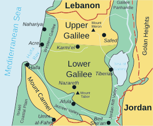
Upper Galilee
[3] According to the first century Jewish historian Josephus, the bounds of Upper Galilee stretched from Bersabe in the Beit HaKerem Valley to Baca (Peki'in) in the north, and from Meloth to Thella.
That is, the term today does not include the portion of Southern Lebanon up to the Litani River, or the corresponding stretches of the Israeli Coastal Plain to the west, or the Jordan Rift Valley to the east.
[13] Following the dissolution of the Ottoman Empire and the Balfour Declaration in which the British Empire promised to create "A Jewish National Home" in Palestine, the Zionist Movement presented to the Versailles Peace Conference a document calling for including in the British Mandate of Palestine the entire territory up to the Litani river — with a view to this becoming eventually part of a future Jewish state.
However, only less than half this area was actually included in British Mandatory Palestine, the final border being influenced both by diplomatic maneuverings and struggles between Britain and France and by fighting on the ground, especially the March 1920 battle of Tel Hai.
This included the highland region of Belad Bechara in Jabal Amel located in South Lebanon,[14] which was at for some time known in Hebrew as "The Lebanese Galilee".
In recent decades, however, this usage has virtually disappeared from the general Israeli discourse, the term "Upper Galilee" being used solely in reference to the part located in Israel.
Safed harbored mysticism and was reminiscent of picturesque villages, which drew artists such as Frenkel, Marc Chagall, Moshe Castel, Mordechai Levanon and others.