Urban area
An urban area[a] is a human settlement with a high population density and an infrastructure of built environment.
According to the definition by the Office for National Statistics, "Built-up areas are defined as land which is 'irreversibly urban in character', meaning that they are characteristic of a town or city.
[14] According to Demographia, these are the 200 largest urban areas in the world by population (as of 2023):[15] Presently, urban data are based on arbitrary definitions that vary from country to country and from year or census to the next, making them difficult to compare.
An Urban Metric System (UMS) has been conceived that could correct the problem,[16] since it allows computing the urban area limits and central points, and it can be applied in the same way to all past, present and future population and job distributions.
The UN principles and recommendations state that due to different characteristics of urban and rural areas across the globe, a global definition is not possible.
[19] Between 150 and 200 million migrant workers work part-time in the major cities, returning home to the countryside periodically with their earnings.
The large "floating populations" of migrant workers make conducting censuses in urban areas difficult;[22] the figures below include only long-term residents.
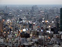
In Japan, urbanized areas are defined as contiguous areas of densely inhabited districts (DIDs) using census enumeration districts as units with a density requirement of 4,000 inhabitants per square kilometre (10,000/sq mi).
[30] In the northern half of the country, most of the population lives in an arc formed by the cities of Lahore, Faisalabad, Rawalpindi, Islamabad, Gujranwala, Sialkot, Gujrat, Jhelum, Sargodha, Sheikhupura, Nowshera, Mardan and Peshawar.
During 1990–2008, city dwellers made up 36% of Pakistan's population, making it the most urbanised nation in South Asia.
[35] As an island city-state, about 5.6 million people live and work within 700 square kilometres (270 sq mi).
[37] The country is divided into 5 regions for planning purposes by the URA, even though as a city state Singapore is defined as a single continuous urban area.
As in other Nordic countries, an urban area (taajama in Finnish) in Finland must have a building at least every 200 m (660 ft) and at least 200 people.
To be considered a town or a city (kaupunki) for statistical purposes, an urban area must have at least 15,000 people.
The largest cities in France, in terms of urban area population (2017), are Paris (12,628,266), Lyon (2,323,221), Marseille (1,760,653), Toulouse (1,360,829), Bordeaux (1,247,977), Lille (1,191,117), Nice (1,006,201), Nantes (972,828), Strasbourg (790,087) and Rennes (733,320).
The largest conurbation is the Rhine-Ruhr region (11 million in 2008[update]), including Düsseldorf (the capital of North Rhine-Westphalia), Cologne, Bonn, Dortmund, Essen, Duisburg, and Bochum.
Unlike in Denmark and Sweden, the distance between each building has to be of less than 50 m, although exceptions are made due to parks, industrial areas, rivers, and similar.
[45] In Poland, official "urban" population figures simply refer to those localities which have the status of towns (miasta).
This distinction may give a misleading impression in some cases, since some localities with only village status may have acquired larger and denser populations than many many smaller towns[46] with most excessive example of Poznań, most spread urban area of the country with population of the city app.
On the other hand, the Katowice urban area with numerous large and medium cities covers 1,468 km and has above 2 million people.
[50] Saint Petersburg, the cultural capital, is the second-largest city, with a population of roughly 5.4 million inhabitants.
[51] Other major urban areas are Yekaterinburg, Novosibirsk, Kazan, Nizhny Novgorod, and Chelyabinsk.
The Southern and Eastern coasts with Barcelona, Valencia and Málaga are more urbanised than the Northern and Western ones.
Urban areas in Sweden (tätorter) are statistically defined localities, totally independent of the administrative subdivision of the country.
[65] In the Canada 2011 Census, Statistics Canada redesignated urban areas with the new term "population centre";[66] the new term was chosen in order to better reflect the fact that urban vs. rural is not a strict division, but rather a continuum within which several distinct settlement patterns may exist.
The Bureau defines an urban area as "a statistical geographic entity consisting of a densely settled core created from census blocks and contiguous qualifying territory that together have at least 2,000 housing units or 5,000 persons.
[68] The largest urban area in the United States is that of New York City and its surrounding suburbs.
The next five largest urban areas in the U.S. are those of Los Angeles, Chicago, Miami, Houston, and Dallas.
[69] 80.0 percent of the population of the United States lives within the boundaries of an urban area as of the 2020 census.
[73] Córdoba has around 1.5 million people living in the urban area, while Rosario, Mendoza and Tucumán have around 1.2 million inhabitants each[73] and La Plata, Mar del Plata, Salta and Santa Fe[73][74] have at least 500,000 people each.