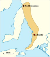
Adelaide
Named in honour of Queen Adelaide of Saxe-Meiningen, wife of King William IV, the city was founded in 1836 as the planned capital for the only freely settled British province in Australia.
[15] Colonel William Light, one of Adelaide's founding fathers, designed the city centre and chose its location close to the River Torrens.
Adelaide's quality of life has ranked consistently highly in various measures through the 21st century, at one stage being named Australia's most liveable city, third in the world.
[30] The site of the colony's capital was surveyed and laid out by Colonel William Light, the first surveyor-general of South Australia, with his own original, unique, topographically sensitive design.
[31] Adelaide was established as a planned colony of free immigrants, promising civil liberties and freedom from religious persecution, based upon the ideas of Edward Gibbon Wakefield.
Wakefield had read accounts of Australian settlement while in prison in London for attempting to abduct an heiress,[32] and realised that the eastern colonies suffered from a lack of available labour, due to the practice of giving land grants to all arrivals.
[dubious – discuss] The first governor of South Australia, John Hindmarsh, clashed frequently with others, in particular the Resident Commissioner, James Hurtle Fisher.
Grey slashed public expenditure against heavy opposition, although its impact was negligible at this point: silver was discovered in Glen Osmond that year, agriculture was well underway, and other mines sprung up all over the state, aiding Adelaide's commercial development.
The city exported meat, wool, wine, fruit and wheat by the time Grey left in 1845, contrasting with a low point in 1842 when one-third of Adelaide houses were abandoned.
Trade links with the rest of the Australian states were established after the Murray River was successfully navigated in 1853 by Francis Cadell, an Adelaide resident.
[41] Adelaide was not as badly hit as the larger gold-rush cities of Sydney and Melbourne, and silver and lead discoveries at Broken Hill provided some relief.
[43] International manufacturers like Holden and Chrysler[48] made use of these factories around the Adelaide area in suburbs like Elizabeth, completing its transformation from an agricultural service centre to a 20th-century motor city.
The government invested more than A$2 billion to build a desalination plant, powered by renewable energy, as an "insurance policy" against droughts affecting Adelaide's water supply.
On 1 March 1954 at 3:40 am Adelaide experienced its largest recorded earthquake to date, with the epicentre 12 km from the city centre at Darlington, and a reported magnitude of 5.6.
Light's selection of the location for the city was initially unpopular with the early settlers, as well as South Australia's first governor, John Hindmarsh, due to its distance from the harbour at Port Adelaide, and the lack of fresh water there.
[78] The benefits of Light's design are numerous: Adelaide has had wide multi-lane roads from its beginning, an easily navigable cardinal direction grid layout and an expansive green ring around the city centre.
The later Labor government elected under Don Dunstan shelved the plan, but allowed the purchased land to remain vacant, should the future need for freeways arise.
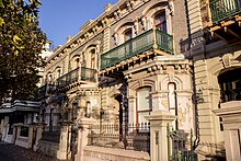
A relative lack of suitable, locally-available timber for construction purposes led to the early development of a brick-making industry, as well as the use of stone, for houses and other buildings.
[130] The "Afghan" community in Australia first became established in the 1860s when camels and their Pathan, Punjabi, Baluchi and Sindhi handlers began to be used to open up settlement in the continent's arid interior.
[131] Until eventually superseded by the advent of the railways and motor vehicles, camels played an invaluable economic and social role in transporting heavy loads of goods to and from isolated settlements and mines.
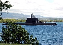
[134] Manufacturing, defence technology, high-tech electronic systems and research, commodity export and corresponding service industries all play a role in the SA economy.
The collapse meant that successive governments enacted lean budgets, cutting spending, which was a setback to the further economic development of the city and state.
[137] The global media conglomerate News Corporation was founded in, and until 2004 incorporated in, Adelaide and it is still considered its "spiritual" home by its founder, Rupert Murdoch.
[138] Australia's largest oil company, Santos, prominent South Australian brewery, Coopers, and national retailer Harris Scarfe also call Adelaide their home.
[147][148][149][150] In summary: Each quarter, The Alternative and Direct Investment Securities Association (ADISA) publishes a list of median house sale prices by suburb and Local Government Area.
[190] In addition to its own WOMAD (WOMADelaide), Adelaide has attracted several touring music festivals, including Creamfields, Laneway, and Groovin' (some since defunct).
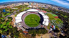
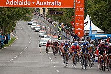
[199] The Grand Prix became a source of pride, and losing the event to Melbourne in a surprise announcement in mid-1993 left a void that has since been filled with the Adelaide 500 for V8 Supercar racing, held on a modified version of the same street circuit.
Design for thrill seekers and rev-heads the facility currently host South Australia's second Supercars motoring event during a round in August.
The Adelaide Metro consists of a contracted bus system including the O-Bahn Busway, 7 commuter rail lines (diesel and electric), and a small tram network operating between inner suburb Hindmarsh, the city centre, and seaside Glenelg.
[206][207] SAHMRI is building a $300 million second facility due to be completed by 2022 to house the Australian Bragg Centre with Australia's first proton therapy unit.