Utah County, Utah
[6] The legislature of the State of Deseret created a county on January 31, 1850,[7] to govern the civic affairs of Utah Valley, which by the 1850s was bustling with newly arrived settlers.
The State of Deseret dissolved soon after (April 5, 1851), but the counties it had set in place continued.
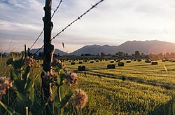
Most of the comparatively level ground is dedicated to agriculture or developed uses, while most of the steep terrain is covered with arid-climate forestation.
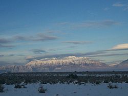
[10] The county generally slopes to the west and north, with its highest point (the northern peak of the twin-peaked Mt.
[12] Utah Valley lies at the center of the county, lined by the mountains of the Wasatch Range on the east.
For county-level census data in 1950 and 1900, Utah counted all non-White and non-Black residents using this category.
There were 184,558 households in Utah County with an average size of 3.57 of which 148,476 (80.4%) were families and 36,082 (19.6%) were non-families.
1 Due to respondents reporting multiple ethnicities, percentages may add up to greater than 100%.
[28] The first sheriff of the county was John T. Willis, who was succeeded by William Madison Wall.
[29] In 2020, Sheriff Mike Smith publicly stated he would not enforce COVID-19 face mask mandates.
Most of the county's population is in the 3rd District, represented by Republican John Curtis, former Provo Mayor.
Much of the county's area however, including Utah Lake, resides in the 4th District currently represented by Republican Burgess Owens.
The county's Republican bent runs right through state and local politics.
Prior to the 1950s, Utah County relied on the U.S. Highway System for local transportation.
[70] However, the highway system retains its significance in Utah County due to the mountainous terrain.
Portions of Highway 89 have become prominent local roads known collectively as 'State Street'.
Utah County has seen significant growth in public transportation over the past 15 years, owing in part to the county's large student population of more than 70,000 commuting to-and-from Brigham Young University (BYU) in Provo and Utah Valley University (UVU) in Orem.
Provo also serves as the southernmost terminus of the FrontRunner, Utah's intrastate commuter rail service.
[72] The Provo FrontRunner station is located on South University Avenue, directly southwest of Amtrak's Provo Station—which is Utah's third westbound stop, after Green River and Helper, for the California Zephyr Amtrak route.