Utah State Route 143
Twenty years later, the route was extended to Cedar Breaks National Monument, and again in 1985 to its present-day eastern end in Panguitch.
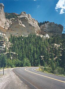
[3] From here, the route climbs past the Vermillion Cliffs,[4] named for their reddish color produced by iron oxides.
[5] Farther up the canyon, the highway passes by the White Cliffs as it enters Dixie National Forest, and begins a steep climb up to Brian Head.
[4] As the route climbs onto the Markagunt Plateau at an elevation of nearly 10,000 feet (3,000 m), it enters the town of Brian Head, Utah's highest incorporated city and the home of Utah's highest ski resort, Brian Head Ski Resort.
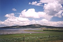
[1] As the highway heads east, it descends through thick aspen forests interspersed with ancient lava fields.
[6] SR-143 continues its descent, heading northeast alongside Panguitch Creek[3][4] as it enters Garfield County and exits Dixie National Forest.
[12] More recently, around the time of European settlement, the area was inhabited by the Southern Paiute people[12] who used much of the Markagunt Plateau for hunting and gathering.
[3] The construction of Interstate 15 (I-15) in the Parowan area caused the state legislature to twice modify the alignment of SR-143.
The two blocks of Main Street overlapping SR-38 were transferred to SR-143, with the remainder of that route deleted and withdrawn from the state highway system.
In this same legislative resolution, there was a provision that the portion of the route alignments inside the boundaries of the national monument would be included as part of the state highway system once the Utah Department of Transportation was granted a right-of-way easement from federal authorities.