Valles Caldera
[1] Hot springs, streams, fumaroles, natural gas seeps, and volcanic domes dot the caldera landscape.
[6] The area has a varied history involving cultural significance, economic resources, scientific studies, and complex geological setting.
[7] Several Native American tribes frequented the caldera for hunting prolific game and gathering obsidian that is common in this area.
Later, as the United States acquired New Mexico as part of the Treaty of Guadalupe Hidalgo in 1848, the caldera became the backdrop for the Indian wars with the U.S. Army.
Bond, a businessman based in nearby Española, ran up to 30,000 sheep in the caldera, significantly overgrazing the land and causing damage from which the watersheds of the landscape are still recovering.
Pat Dunigan did not obtain the timber rights, however, and the New Mexico Lumber Company logged the property heavily - removing significant amounts of old-growth douglas fir and ponderosa pine.
As some sites of the Baca Ranch are sacred and of cultural significance to the Native Americans, 5,000 acres (20 km2) of the purchase were obtained by the Santa Clara Pueblo, which borders the property to the northeast.
In 2010, the Trust admitted that it would be unable to achieve financial self-sustainability, having raised only about $850,000 of the $3 million needed to manage the property each year.
Environmentalists lobbied for the more inclusive protections of national park status instead of the Trust model, but then-Senator Pete Domenici (R) insisted on the experimental approach as a condition for his support for public purchase.
[14] In July 2011, the Las Conchas Fire, started by a power line on nearby private land, burned 30,000 acres (120 km2) of the Valles Caldera National Preserve.
[15] The Jemez Mountains and surrounding areas of the southwest incorporate dry climates, grasslands, and certain tree species (like Pinon) that evolved to exist with wildfires.
Research studies have focused on the fundamental processes of magmatism, hydrothermal systems, ore deposition, and glassy rhyolites.
The younger Tshirege Member of the Bandelier Tuff was formed during the Valles Caldera eruption 1.23 million years ago.
[2] The now eroded and exposed orange-tan, light-colored Bandelier Tuff from these events creates the stunning mesas of the Pajarito Plateau.
After the initial caldera-forming eruption at Valles, the Redondo Peak resurgent dome was uplifted beginning around 1.2 million years ago.
Seismic investigations show that a low-velocity zone lies beneath the caldera, suggesting the presence of partial melt within a remaining magma chamber at between 5 and 15 km depth.
This volcanic field lies at the intersection of the Rio Grande Rift, which runs north–south through New Mexico, and the Jemez Lineament, which extends from southeastern Arizona northeast to western Oklahoma.
[24] NASA used the caldera in October to November 1964 and again in September 1966 to geologically train the Apollo Astronauts in recognizing volcanic features, such as ash flow tuffs, pumice air falls, and rhyolite domes.
Originally, the Fenton Hill site was chosen as an EGS laboratory in hopes that the proximity to Valles caldera would increase the temperature of the bedrock, thus requiring shallower drill depths.
[32] The experiments demonstrated that a potential EGS reservoir must be characterized by low permeability, crystalline basement rock with no active faults or joints.
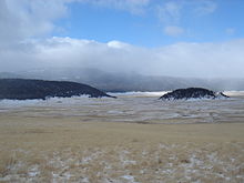
This is due to heavy browsing by elk and cattle and because of frequent grass fires of human and natural origin which kill the lower branches on the Engelmann spruce, Douglas-fir and Ponderosa pine that populate the uplands around the lower-elevation Montane grasslands dominating the bottoms of the calderas.
Through the VCNP's limited grazing program, it feeds hundreds of cattle in the summer and thousands more of elk in the warm seasons, in drought winters, and during most of the year.
Some of these locations include exterior sets, such as the weathered "ranch house" that can be seen from the highway in Valle Grande, and a small "town".