Sébastien Le Prestre, Marquis of Vauban
Viewing civilian infrastructure as closely connected to military effectiveness, Vauban upgraded many of France's major ports, as well as new projects like the Canal de la Bruche, which is still in use today.
His advocacy of giving up territory for a more coherent and defensible border was unusual for the period; the boundaries of the French state he proposed in the north and east have changed very little since.
[2] Sébastien le Prestre de Vauban was born in May 1633, in Saint-Léger-de-Foucheret, renamed Saint-Léger-Vauban by Napoleon III in 1867, in the Yonne, part of what is now the Bourgogne-Franche-Comté region.
[10] At the time, it was common for young men to follow the lead of local powerful magnates which would explain the future eagerness of the crown to offer him service in the royal army.
Vauban first saw action at Clermont-en-Argonne and was noticed by Condé as a diligent and energetic soldier that took a keen interest in the practices of siege warfare even at such a young age and he was sometimes entrusted with directing the improvement of local fortifications.
[12] Under the terms of the Treaty of the Pyrenees, Spain ceded much of French Flanders, and Vauban was put in charge of fortifying newly acquired towns such as Dunkirk.
[citation needed] The first fortification Vauban designed was the 1673 siege of Maastricht, although he was subordinate to Louis, who ranked as the senior officer present, and thus took credit for its capture.
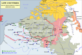
[14] After 1673, French strategy in Flanders was based on a memorandum from Vauban to Louvois, Minister of War, setting out a proposed line of fortresses known as the Ceinture de fer, or iron belt (see Map).
[17] The numbers needed to conduct a siege, and prevent interference from opponents meant armies of the Nine Years' War often exceeded 100,000 men, sizes unsustainable for pre-industrial societies.
Capturing Lille cost the Allies 12,000 casualties and most of the 1708 campaigning season; the lack of progress between 1706 and 1712 enabled Louis to negotiate an acceptable peace at Utrecht in 1713, as opposed to the humiliating terms presented in 1707.
His fortifications were designed for mutual support, so they required connecting roads, bridges and canals; garrisons needed to be fed, so he prepared maps showing the location of forges, forests and farms.
Although his work was confiscated and destroyed by royal decree, the use of statistics to support his arguments "... establishes him as a founder of modern economics, and precursor of the Enlightenment's socially concerned intellectuals.
Initially reliant on existing concepts, he later adapted these on lines set out in his memorandum of March 1672, Mémoire pour servir à l'instruction dans la conduite des sièges.
Their importance was heightened by Louis XIV, who viewed them as low-risk opportunities for demonstrating his military skill and increasing his prestige; he was present at 20 of those conducted by Vauban.
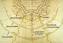
[29] Three parallel trenches were dug in front of the walls, the earth thus excavated being used to create embankments screening the attackers from defensive fire, while bringing them as close to the assault point as possible (see diagram).
Artillery was moved into the trenches, allowing them to target the base of the walls at close range, with the defenders unable to depress their own guns enough to counter this; once a breach had been made, it was then stormed.
While the 'Van Coehoorn method' sought to overwhelm defences with massive firepower, such as the Grand Battery of 200 guns at Namur in 1695, Vauban preferred a more gradual approach.
[34] As few states could afford large standing armies, defenders needed time to mobilise; to provide this, fortresses were designed to absorb the attackers' energies, similar to the use of crumple zones in modern cars.
[28] The principles of Vauban's 'second system' were set out in the 1683 work Le Directeur-Général des fortifications, and used at Landau and Mont-Royal, near Traben-Trarbach; both were advanced positions, intended as stepping-off points for French offensives into the Rhineland.
[39] Fort-Louis was another new construction, built on an island in the middle of the Rhine; this allowed Vauban to combine his defensive principles with town planning, although like Mont-Royal, little of it remains.
[40] The French retreat from the Rhine after 1697 required new fortresses; Neuf-Brisach was the most significant, designed on Vauban's 'third system', and completed after his death by Louis de Cormontaigne.
[50] His defensive fortifications dated far more quickly, partly due to the enormous investment required; Vauban himself estimated that in 1678, 1694 and 1705, between 40 and 45% of the French army was assigned to garrison duty.