Verdon Gorge
[citation needed] The dawn of the Quaternary period had large-scale glaciation, transforming water pockets and lakes into rivers of ice, which remodeled the topography, scouring and striating the landscape.
[citation needed] The Verdon's riverbed was scoured for a second time of the accumulated coral and limestone sediments, by a water delivery rate nearing 2000 to 3000 cubic metres per second.
On 10 July 2006, the Council of State annulled the declaration of public use of a project by EDF relating to a proposed high-voltage line which would have had to pass through the Verdon Gorge.
[citation needed] This decision ended 23 years of struggle by public groups and associations of environmental defence to preserve a site of exceptional natural interest, of which a part contains protected animal and plant species.
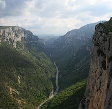
[2][3] The source of the Verdon is close to the col d'Allos hill in the Trois Eveches mountain range, whence it continues, flowing into the Durance river near Vinon-sur-Verdon after traveling 175 kilometres.
[citation needed] For some distance the Verdon Gorge forms the border between the départements of Var to the south and Alpes-de-Haute-Provence to the north in the Provence-Alpes-Côte d'Azur région.
The Imbut, also known as Embut or Embucq, is an area where the Verdon disappears underground, beneath enormous rock structures, before re-emerging above ground.
[citation needed] Martel had visited the Verdon in 1905 as an employee of the Southeast Electricity Company, carrying out precise geological surveys of the river.
On 11 August, he and his team (explorer Armand Janet, schoolmaster Isidore Blanc, geographer Cuvelier, plaus Baptistin Flory, Fernand Honorat, Prosper Marcel, and Tessier Zurcher)[citation needed] began an expedition of the region.