Via Augusta
[1][2] Approximately 1,500 km (930 mi) long, the Via Augusta was built to link Spain with Italy, running from the southwestern coastal city of Gades (Cádiz) to the Pyrenees Mountains along inland valleys parallel to the coast of the Mediterranean Sea.
At Martorell, the ancient Via crosses the river Llobregat on the Pont del Diable,[10] which dates from the High Middle Ages (circa 1289) in its current form.
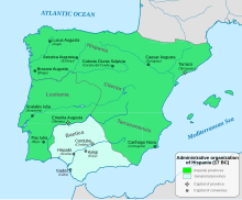
Hispania, the Roman name for the Iberian Peninsula, included what is now Spain, Portugal, Andorra, and the southernmost part of France.
The strategic position of Roman Barcelona (Barcino) on a spur road of the Via Augusta allowed the city's commercial and economic development.
The Roman Arch of Cabanes, in the flat area known as Pla de l'arc, 19 kilometres (12 mi) northwest of Castellón in the Valencian Country, crosses the Via Augusta,[22] which followed the inland valley in the province.
[23] The Via Augusta is documented and referenced in two central places in Valencia: the first is next to the Valencia Cathedral in the Almoina Archaeological Centre, which houses archaeological excavations made between 1985 and 2005 that revealed stratigraphic layers representing successive eras of the city's history,[24] and the second place is next to the old Palace of the Borgias, now the Valencian Parliament.
/ MAXIMVS / MILLE PASSVS XXVIIIThe inscription translated to English reads: Emperor Caesar Augustus, son of the Divine, Consul for the 11th time, his 16th year of tribunal power, General in 14 campaigns and Chief High Priest, mile 28 [from Carthago Nova (Cartagena) towards Eliocroca (Lorca}][27]The Via Augusta was the great imperial road of Spain, and as a continuation of the Vias Julia Augusta, Aemilia, and Flaminia, it formed a major link in a chain of roads connecting Rome with the Atlantic Ocean.
[32] Its usage allowed the development of cities such as Valentia (Valencia), Saguntum (Sagunto), Lucentum (Alicante), Saetabis (Xàtiva), and Ilici (Elche).
[34] Starting from Coll de Pertús pass in the Pyrenees, the Via Augusta ran south and southwest to the upper reaches of the River Baetis, and from that area on through Baetica to Gades.
The river in that region formed the boundary between Baetica and Tarraconensis, and there a bridge with an arch, the Ianus Augusti, was erected in honor of Augustus.
The milestones were cylindrical stone columns of granite or sandstone between 2 and 3 metres high and 50 to 80 cm in diameter, set on a square base.
[39] He and his advisors set about devising an ambitious programme to restructure the administration of the territory, its primary objectives being the establishment of new cities, the construction of roads connecting them, and the distribution of large areas of land to be parcelled out among veteran professional soldiers.
Asturica Augusta, the terminus of the "silver route", was an important junction, where the highways to Lusitania and the Cantabrian coast intersected.
In Hispalis the road joined the branch of the Via Augusta which started in Acci (also Accitum) and veered inland to Corduba, Astigi (Écija), and Carmo.
[44] There was a road built by him from Ilerda to Caesaraugusta, crossing the Ebro by a wooden bridge according to Strabo, and apparently one from Aesuris to Pax Julia, up the course of the river Anas.
In contrast to Gaul, where Agrippa had laid out four or five roads radiating from a central hub, here there was the perimeter of a wheel, so to speak, and it was the task of succeeding emperors to fill in the spokes and build more direct cross-country routes.
These roads remained strategically important, but their main purpose was for general communications, as shown by an inscription on a fragmentary milestone found near Corduba (Córdoba).
This section of the road was designated a via miltaris, according to the inscription: VIAM AVGVSTAM MILITAREM / VETVSTATE CORRVPTAM RESTITVIT.