Via Tiberina
The via Tiberina, which owes its name to its path that follows that of the Tiber river, is one of the oldest roads in the area north of Rome: although there are references to it only in documents from the Constantinian era,[1] its use is testified since prehistoric times, as a set of sheep tracks that connected the archaic centers located along the river, thus playing the role of a way of great communication, similarly to what happened on the other side with the Via Salaria.
[2] It is also hypothesized that the Tiberina coincided in the area with the ancient Via Campana, a road used by the Etruscans since the 7th century BC to transport inland the salt extracted to the salt-field at the mouth of the Tiber.
Although it lost part of its importance as a connection with Umbria and the upper Sabina with the construction of the Via Flaminia, around 220 BC,[6] the Tiberina nevertheless remained, both in the republican and in the imperial age, a rapid and safe to transport the products of the surrounding fertile territory to the Roman market,[7] as well as a necessary support for river navigation[8] and with a local viability function.
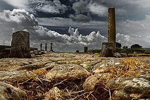
[9] Later, with the construction of the Flaminia, the route of the two roads was common from Ponte Milvio to Prima Porta (ad gallinas albas): here, immediately after the bridge over the ditch of Prima Porta, the Tiberina branched off continuing to follow the course of the river and crossing the ancient ager capenate arriving at the sanctuary of Lucus Feroniae.
From here it continued, always along the Tiber, towards the area of the current Ponzano Romano until it crosses the Treja [it] river near Falerii Veteres (Civita Castellana).