White Nile
[7] The source of the Nile can be considered to be either the Ruvyironza, which emerges in Bururi Province, Burundi[8] (near Bukirasaz), or the Nyabarongo, which flows from Nyungwe Forest in Rwanda.
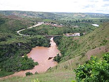
During much of the insurgency of the Lord's Resistance Army, Karuma Bridge, built in 1963 to help the cotton industry, was the key stop on the way to Gulu, where vehicles gathered in convoys before being provided with a military escort for the final run north.
In 2009, the government of Uganda announced plans to construct a 750-megawatt hydropower project several kilometres north of the bridge, which was scheduled for completion in 2016.
[12] Just before entering Lake Albert, the river is compressed into a passage just seven meters wide at Murchison Falls, marking its entry into the western branch of the East African Rift.
[16] The southern stretch of the river encounters several rapids before reaching the Sudan plain and the vast swamp of the Sudd.
[17] The 120 kilometers of White Nile that flow east from Lake No to the mouth of the Sobat are very gently sloping and hold many swamps and lagoons.
[20] When in flood, the Sobat River tributary carries a large amount of sediment, adding greatly to the White Nile's pale color.
Downstream from Malakal lies Kodok, the site of the 1898 Fashoda Incident that marked an end to the Scramble for Africa.