Vosges
Together with the Palatine Forest to the north on the German side of the border, they form a single geomorphological unit and low mountain range of around 8,000 km2 (3,100 sq mi) in area.
The latter area logically continues the same Vosges geologic structure but traditionally receives this different name for historical and political reasons.
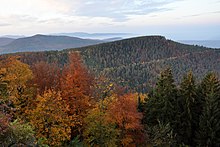
The elongated massif is divided south to north into three sections: In addition, the term "Central Vosges" is used to designate the various lines of summits, especially those above 1,000 m (3,300 ft) in elevation.
From a geological point of view, a graben at the beginning of the Paleogene period caused the formation of Alsace and the uplift of the bedrock plates of the Vosges, in eastern France, and those in the Black Forest, in Germany.
These consist of a large Carboniferous mountain eroded just before the Permian Period with gneiss, granites, porphyritic masses or other volcanic intrusions.
The north, south and west parts are less eroded by glaciers, and here Vosges Triassic and Permian red sandstone remains are found in large beds.
[7] Both the Vosges and the Black Forest were formed by isostatic uplift in response to the opening of the Rhine Graben, a major extensional basin.
The main air streams come generally from the west and southwest, so the Alsatian central plains just under the Hautes-Vosges receive much less water than the south-west front of the Vosges Mountains.
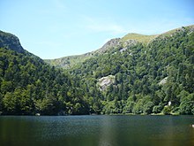
In the High Moselle and Meurthe basins, moraines, boulders and polished rocks testify to the former existence of glaciers which once covered the top of the Vosges.
On the lower heights and buttresses of the main chain on the Alsatian side are numerous castles, generally in ruins, testifying to the importance of this crucial crossroads of Europe, violently contested for centuries.
The demarcation line stretched from the Ballon d'Alsace in the south to Mont Donon in the north with the lands east of it being incorporated into Germany as part of Alsace-Lorraine.
[11] On 20 January 1992 Air Inter Flight 148 crashed into the Vosges Mountains while circling to land at Strasbourg International Airport, killing 87 people.
By contrast, those parts of the northern Vosges and the whole of the Wasgau, which lie north of the Breusch valley, fall within the Germanic-speaking area because, from Schirmeck the historical linguistic boundary turns to the northwest and runs between Donon and Mutzigfelsen heading for Sarrebourg (Saarburg).