Frisian Islands
Most of the Wadden Sea Islands are environmentally protected areas, and an international wildlife nature reserve is being coordinated between the Netherlands, Germany and Denmark.
Natural gas and oil drilling continue, however, and in the vicinity of the Ems, Weser and Elbe estuaries, ship traffic causes tension between wildlife protection and economic values.
With the melting of the ice caps, the sea level rose, reaching the current coast line around the beginning of the Holocene era, approximately 7,000 years ago.
Tidal action transported large quantities of sand to form a line of dunes extending over 500 kilometres (310 mi) from the Netherlands to the mouth of the river Elbe in Germany.
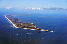
Beyond the core, however, the same processes are at work, as is particularly evident on Sylt, where the south of the island threatens to be broken away and the harbour at List in the north silts up.
The Roman naturalist Pliny, writing in the first century AD, described the Frisians as ... ... people who live without trees or shrubs.
There, two times in each period of a day and a night, the ocean with a fast tide submerges an immense plain, thereby the hiding ... whether the area is sea or land.
There this miserable race inhabits raised pieces ground or platforms, which they have moored by hand above the level of the highest known tide.
They braid ropes of sedges and rushes from the marshes with which they make nets to be able to catch fish, and they dig up mud with their hands and dry it more in wind than in the sun, and with soil as fuel they heat their food and their own bodies, frozen in northern wind.
At the Frisian Peins (near Franeker), a 40-meter section of dike has been discovered that is thought to date from the 1st or 2nd century BC.
The dunes south of the Wadden Sea were also liable to this process, but human intervention prevented the many storm surges from changing the coast of the provinces North Holland and South Holland into separate islands with Wadden mudflats behind them.
In 2019, Dutch maritime investigators unearthed a 16th century shipwreck during a search for containers from MSC Zoe.
According to Holland’s National Office for Cultural Heritage, the ship was built circa 1540 in the Netherlands during the reign of Charles V. Researchers also found copper plates with emblem of the Fugger family and wooden beams with a sleek hull about 30 metres long.
Nordstrand is now so much linked to the rampart by dikes that it is difficult to define it as an island, and also Langeness, Oland, Nordstrandischmoor, Hamburger Hallig, Sylt, and Rømø are all reachable by dams.
The names of all these places suggest this is the transition area between island and shoal (plaat in Dutch).
(from West to East and South to North) The German islands have a surface of 448.52 km² (173 sq.