Wakkanai
After Japan regained Karafuto following its victory in the Russo-Japanese War in 1905, Wakkanai rose to prominence as a gateway to this reclaimed territory.
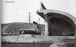
[2] This improved transport network enabled the commercial digging of local coal mines, which had remained untouched due to their remote location.
All coal mines in the area were closed by the 1970s, and Wakkanai's primary industries shifted to fishing, dairy farming, and tourism.
In 1995, the ferry route between Wakkanai and Sakhalin was reestablished for the first time since 1945 but ceased operations in 2015 due to low demand.
A Japanese settlement was established in 1685 by Matsumae Domain as a trading post and key point for guarding northern Japan and the exploration of Sakhalin.
At the shore end there was a huge winching mechanism capable of hauling subs up into the partially enclosed structure where they could be repaired while completely out of the water.
Built into the hills above the city there were several reinforced concrete bunker-type caves where (anecdotally) they were used either to store ammunition and armament, or as air raid shelters for the civilian populace.
Japan's northernmost point, Cape Sōya, is located in Wakkanai, which is on a peninsula jutting towards Sakhalin Island in Russia, which is 43 kilometers (27 miles) away.
The eastern mountain range is called the "Sōya Hills" and is a periglacial landform that has been selected as a "Hokkaido Heritage Site".
The lowlands between the western hills and the Sea of Japan are sand dunes and wetlands, and are part of the Rishiri-Rebun-Sarobetsu National Park.
Wakkanai has a humid continental climate (Köppen: Dfb) typical of Hokkaido but with strong influence of the ocean as island portions near the great land masses (such as the smaller islands of Nova Scotia),[7] with cold winters, warm summers and generally heavy precipitation from the Aleutian Low, whose winds hit the city direct from the Sea of Japan but with strong oceanic influence (46 °F).
Wakkanai has a mayor-council form of government with a directly elected mayor and a unicameral city council of 18 members.
In terms of national politics, the city is part of the Hokkaido 12th district of the lower house of the Diet of Japan.
[21] During particularly strong winter months if the weather is unfavorable, flights will often be diverted to nearby Asahikawa airport 155 miles (250km) south of Wakkanai.
[22] JR Hokkaido - Sōya Main Line The Sōya limited express runs once a day to and from Sapporo, while the Sarobetsu runs twice a day to and from Asahikawa, with a change of trains to either a Lilac or Kamui limited express service at Asahikawa required to reach Sapporo.