Waldems
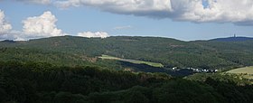
Waldems is located in the Taunus in a widely wooded setting at the northwest foot of the Feldberg massif at 250 to 629.3 m above sea level, the southern hilltop of the mountain Windhain, which is the highest point of the district Rheingau-Taunus-Kreis, rising east of the constituent municipality of Wüstems.
The municipality's six Ortsteile are Bermbach, Esch (administrative seat), Niederems (with Reinborn), Reichenbach, Steinfischbach and Wüstems.
For many centuries this was borderland; the Limes ran nearby, and later, the Electoral Mainz's, Hesse's and Nassau's spheres of influence all came up against each other here.
The constituent municipality of Esch goes back to a settlement from the 6th century, having had its first documentary mention as Eschze in the rent register of the archive deacon at Dietkirchen.
Near the constituent municipality of Steinfischbach are found in the form of the barrows Totenkopf and Goldkessel clues to an early settlement.
Nearby there were iron ore prospecting and a quarry for millstones, road gravel, cobblestones and border stones.
The name's first syllable, Wüst, likely derives from Wüstungen (German for “abandoned settlements”) and refers to a forsaken village or rural area.