Walls of Genoa
In Roman times the original centre of Genoa, on the Sarzano hill, may have been defended by a wall, but there is no archaeological or documentary evidence of its existence.
Some small settlements (housing mainly workmen and artisans), which had grown around churches, monasteries, and feudal palaces, remained outside the walls.
In the 13th century, the Old Pier peninsula, at the southern limit of the port, was also included inside the walls, thus completing the fortifications on the sea side of the city.
Fearing the possibility of new attacks by the French army, he promoted the modernization of the city walls, projected by Giovanni Maria Olgiati [it] and carried out in the third decade of the 16th century.
The “Barbarossa walls” and their 14th-century extensions were modernized by replacing the old square towers with triangular bastions and building new curtains with a counterscarp profile.
The view of Genoa from the sea is characterized by the line of New Walls with their fortifications, on the ridge of the hills, above the hilly quarters which grew after World War II; coming from the north, by train or car, the first visible structure is the mass of Fort Diamante, high on the mount on the left bank of the Val Polcevera, and the Fort Fratello Minore.
Although this defensive wall had already been suggested in 1568, the government of Genoa began the work in 1626, following the failed attack on 10 May 1625 of a French-Piedmontese army at the Pertuso Pass (where, in memory of the event, was later built the Shrine of Nostra Signora della Vittoria, meaning "Our Lady of Victory").
In less than four years, between 1629 and 1633, an army of diggers, bricklayers, and stonemasons (eight hundred, according to some sources, even three thousand according to others), divided into twenty-eight teams, raised curtains and bastions along the two ridges overlooking the valleys of Polcevera and Bisagno.
Supervision of the work was entrusted to Ansaldo De Mari with the cooperation of the Lombard architect Bartolomeo Bianco[1] The “New Walls” extended for almost twenty kilometers, of which seven were along the coastline.
The city's urban expansion eastward in the last decades of the 19th century caused the demolition of one of the most powerful and evocative parts of the New Walls, the so-called “Fronti Basse”, a huge rampart that ran straight, with two large bastions in the plain on the right bank of the Bisagno.
With the 17th-century expansion, the walls along the coast were reinforced with new bastions and extended beyond St. Thomas Gate to Capo Faro, where they met those descending along the western ridge.
Due to port expansion, most of the walls along the sea were demolished; only a short stretch survives, recently enhanced with a walk from the ferry terminal to the lighthouse.
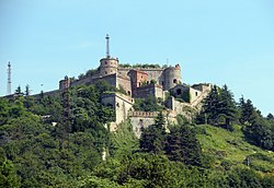
During the 18th century and the first half of the 19th, along the perimeter of the walls were built some fortifications, including Castellaccio, Sperone (on the top of Mount Peralto), Begato, and Tenaglia.
After the annexation of the Napoleonic Ligurian Republic to the Kingdom of Sardinia, decided by the Congress of Vienna in 1814, the Savoy government (1815–1840) built a series of forts, towers, and coastal batteries, making Genoa the best equipped fortress in the Mediterranean.