Uunartoq Qeqertaq
Members of the scientific community believe this newly discovered island is a direct result of global warming.
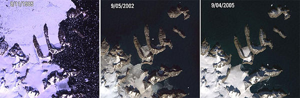
[2] Despite a general lack of suitably detailed maps, Michaels found a map published by Ernst Hofer, a photographer who did aerial surveys of the area in the early 1950s, which showed the Warming Island landmass unconnected to Greenland.
[2] Dennis Schmitt countered Michaels' theory in an article by New York Times reporter Andy Revkin, contending that Hofer's map is inaccurate.
"[4] Michaels explained that Hofer included the map in his book "so as to place his pictures and stories in context.
The island was also part of a 2011 controversy when it was included in the Times Atlas of the World, along with a revised depiction of the Greenland ice sheet that showed a 15% reduction.