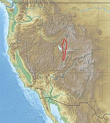
Wasatch Range
[6] Since the earliest days of European settlement, most of Utah's population has chosen to settle along the range's western front, where numerous rivers exit the mountains.
Today, 85% of Utah's population lives within 15 miles (24 km) of the Wasatch Range, mainly in the valleys just to the west.
This great snowfall, with its runoff, made possible a prosperous urban strip of some 25 cities along nearly 100 miles (160 km) of mountain frontage.
The snow and nearby ski resorts helped Salt Lake City gain the right to host the 2002 Winter Olympics.
Dirt roads readily drivable in passenger cars with moderate clearance stretch up from Park City, Heber, and Big Cottonwood Canyon.
This horizontal compression caused thin skinned imbricated thrust faults resulting in as much as 50% crustal shortening of the western North American Plate.
[8] The Wasatch anticlinorium represented the furthest eastern margins of these Sevier origin imbricated thrusts.
The current Wasatch range continues to grow via normal faults as the valley drops in periodic motion.
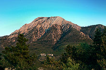
The Colorado Plateau comes to its northwest corner as it meets the southern end of the Rocky Mountains.
The Cottonwoods, a particularly rugged and dense area just east of the Salt Lake Valley, shelters small mountain coves that harbor four world-famous ski resorts (Alta, Brighton, Solitude, and Snowbird).
The Denver and Rio Grande Western Railroad had a line through the Wasatch Range via Soldier Summit Pass and Spanish Fork Canyon.
Now operated by the Union Pacific Railroad, the line is used by freight trains and Amtrak's California Zephyr.
Common trees include Douglas fir (Pseudotsuga menziesii), subalpine fir (Abies bifolia), Engelmann spruce (Picea engelmannii), Colorado blue spruce (Picea pungens), and quaking aspen (Populus tremuloides).
Ponderosa pine (Pinus ponderosa), while abundant elsewhere in Utah is not common in this mountain range, except in plantations in Big Cottonwood Canyon southeast of Salt Lake City and in Logan Canyon, east of Logan.
Many of the valley bottoms at one time were occupied by basin big sagebrush (Artemisia tridentata ssp.
[14] In addition to ski resorts, there are hundreds of miles of mountain biking and hiking trails winding through the canyons and alpine valleys of the Wasatch Range.
There is rock climbing and mountaineering on the towering limestone, granite, and quartzite peaks and in many of the surrounding canyons.
The Utah Native Plant Society conducts regular walks from spring until fall along the foothills of the central Wasatch Front and in adjoining canyons as the season progresses.