Washington Boulevard (Arlington)
[3] Washington Boulevard begins as a one-way residential street heading westbound in East Falls Church, parallel to Interstate 66 (Custis Memorial Parkway).
An intersection with Sycamore Street provides access to the East Falls Church Washington Metro station, which serves the Orange and Silver Lines.
[1] Continuing east in Arlington County, Washington Boulevard intersects Glebe Road (State Route 120) as it enters Ballston.
Glebe Road also provides access to I-66 east at exit 71, just north of Washington Boulevard.
The boulevard now continues east without a signed route number, passing through the Virginia Square and Clarendon neighborhoods.
[1] Beyond 10th Street, Washington Boulevard takes a more southern direction and enters the Lyon Park neighborhood.
An interchange with Second Street South provides to the Penrose neighborhood as well as the historic Fort Myer, now part of Joint Base Myer–Henderson Hall.
Washington Boulevard also crosses the Columbia Pike (State Route 244) by way of the Freedmans Village Bridge.
The Mixing Bowl also has ramps to and from Arlington Ridge Road and Army Navy Drive, providing access to Pentagon City.
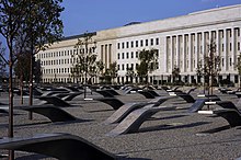
[1] East of the interchange, Washington Boulevard turns north, meeting the eastern terminus of SR 244 at a partial cloverleaf interchange which also serves the south parking lot of The Pentagon, the Pentagon Memorial, and the United States Air Force Memorial.
On September 11, 2001, many commuters and drivers witnessed the hijacked American Airlines Flight 77 as it passed directly over Washington Boulevard and crashed into The Pentagon.
Due to budget constraints, the bridge had to be scaled down, lacking the bicycle paths and other touches originally planned.
The trail was originally built concurrent with the Pentagon in 1943 as an unpaved path, but in 1993 the county made plans to pave and grade it,[11] which was done in the late 1990s.