Washington County, Utah
They were located along the Virgin River, in the warmer climate below the central Great Basin, which was for decades called "Utah's Dixie".
Heberville,[6] Pintura and Toquerville followed in 1858, Grafton, Harrisburg and Pine Valley in 1859, Adventure in 1860, Duncans Retreat, Northrop,[7] Shonesburg[8][7] and St. George in 1861.
[9] Fort Harmony, Adventure, and Northrup were abandoned, and Santa Clara, St. George, Washington, Harrisburg, Heberville, Grafton, and Duncans Retreat were nearly destroyed by the Great Flood of 1862 that followed 44 days of rainfall in January and February 1862.
[13] The county's highest point is Signal Peak in the Pine Valley Mountains, at 10,369 ft (3,160 m) ASL.
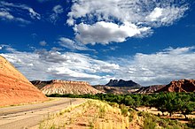
[15] Washington County is made up of three major geographic areas; the Colorado Plateau in the east-northeast, the Great Basin in the northwest, and the Mojave Desert in the south-southwest.
To combat the sprawl (which threatens many nature reserves and increases congestion), growth and promotion are projected inward to the central area of St. George, with many new infill developments being planned and constructed.
Large irrigated farms have been sold to commercial and residential developers to make way for the anticipated need for more housing and business.
The western portion of the urban area contains the suburbs of Santa Clara and Ivins, and the neighborhoods of Green Valley, Dixie Downs, Sunset, and Tonaquint.
Due to this area's proximity to Snow Canyon State Park, this has resulted in the construction of many resort-style communities and gated subdivisions such as Entrada, Kayenta, and the Palisades, with homes often exceeding $1,000,000 in price.
The SR-7 freeway, also known as Southern Parkway, has been built as a beltway to accommodate future growth in the southeastern portion of St. George and Washington.
Despite its scenic location amid red sandstone, lava fields, and the backdrop of the Pine Valley Mountains, the northern area of St. George is almost entirely undeveloped due to the Red Cliffs National Conservation Area, which protects a variety of endangered wildlife and unspoiled desert.
The only communities in northern St. George are The Ledges and Winchester Hills in the west, and Green Springs, near Washington, in the east.
While the community of Winchester Hills has existed for many decades, The Ledges is a newer development met with significant controversy.
This has led many to believe that the beauty of Snow Canyon is in jeopardy due to the City of St. George's willingness to sell the land around the park to private companies.
On the opposite end of the city is Green Springs, an upscale multimillion-dollar development that consists of a golf course and many distinct gated and non-gated housing communities.
Because this locale is disconnected from the rest of the area by undeveloped swaths of land, it is still usually considered distinct from urban St. George, though this may change in the future due to anticipated development that will connect these cities.
This area is more farm-based and rural than St. George, but is still experiencing rapid expansion in commercial, industrial, and residential development like the rest of the region.
Veyo and Dammeron Valley, also near the center of the county, are primarily ranching towns, with most houses situated on large plots of land.
The town contains a small grocery store and multiple gas stations but is very quaint and rural when compared to the urban area of St. George.
The county includes an area along the Old Spanish Trail called Mountain Meadows, just south of Enterprise on SR-18.