Water board (Netherlands)
The concept of a coordinating "High Water Authority" (Hoogheemraadschap) originated in what now is the province of South Holland in the 12th century.
Fertile soil and peatlands often were located near rivers, thus engineering water courses was part of daily life for farmers, landowners and peat extractors.
Ancient Roman settlements from 50 - 350 AD built harbours, riverside enforcements, waterdraining canals, dikes and mounds.
From the year 1000 onward, continuing problems in water management in wide areas along the Rhine river between Utrecht and the North Sea caused farmers, landowners and civilians with administrative responsibilities to collaborate.
Around 1122 in the area around Wijk bij Duurstede, southeast of Utrecht, a collaborative water household organisation was founded to build and maintain a dam in the Rhine.
[1] In Friesland in the 12th century the right to build a sea dike was granted, and in the area around Leiden a water household managing collaboration was established.
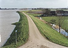
Nowadays around 26 percent of the Netherlands' surface is at or below mean sea level[2] and several branches of the Rhine-Meuse-Scheldt delta run through this relatively small country.
As the structures got more extensive and complex, councils were formed by people with a common interest in controlling the water levels of their land.
From 1408 on, with the first at Zoeterwoude, wind-operated machines (windmills) are being installed along the Old Rhine, to pump water from the lowlands into the river and drainage canals.
The ever-present threat of loss of life, land, animals and goods required short lines of communication between authorities and the people who did design, build and maintain the infrastructure.
This early form of local government played a role in the development of a political system in the Netherlands that was decentralised and dependent on communal cooperation.
The historic buildings that used to house the water boards, called gemeenlandshuis or waterschaphuis, can be found at the heart of many Dutch towns.
However, the word hoogheemraadschap is still used by some Dutch water boards for historical reasons or when several waterschappen are grouped together into a larger regional body.
Water boards levy taxes to finance the work, they have the authority to penalize offenders through means of administrative measures.
To control quality of surface water (canals, lakes, ponds and streams), water boards fulfill several tasks: policy making, planning and building of projects, maintenance, innovation, issuing permits (sewage discharge requires a permit) and treatment of sewage and by-products.
The constituencies of members of the general administrative body are the various categories of stakeholders: landholders, leaseholders, owners of buildings, companies and all residents.
The nature of the interest and financial contribution are factors in determining how many representatives each category may have on the water board.
The general administrative body elects some of its own members to sit on the executive board, called the college van dijkgraaf en heemraden.
Except for the chairperson (the dijkgraaf, see below) these executive board members, called heemraden or hoogheemraden in Dutch, represent five types of stake holders: local residents, industry (factories and industrial buildings), municipalities (urban areas), farmers and land-owners of agricultural land, and natureconservation parks.
The territory of a water board generally covers several municipalities and may include areas located in two or more provinces.