Holland
[4] However, some in the Netherlands (particularly those from regions outside Holland or the west) find it undesirable or misrepresentative to use the term for the whole country.
[5] This example of pars pro toto or synecdoche is similar to the tendency to refer to the United Kingdom as "England",[9][10] and developed due to Holland's becoming the dominant province and thus having the majority of political and economic interactions with other countries.
Gradually, its regional importance increased until it began to have a decisive, and ultimately dominant, influence on the History of the Netherlands.
In the 16th century the county became the most densely urbanised region in Europe, with the majority of the population living in cities.
He was deposed in 1581 by the Act of Abjuration, although the kings of Spain continued to carry the titular appellation of Count of Holland until the Peace of Münster signed in 1648.
In the Dutch Rebellion against the Habsburgs during the Eighty Years' War, the naval forces of the rebels, the Watergeuzen, established their first permanent base in 1572 in the town of Brill.
The largest cities in the Dutch Republic were in the province of Holland, such as Amsterdam, Rotterdam, Leiden, Alkmaar, The Hague, Delft, Dordrecht and Haarlem.
A strong impression of Holland was planted in the minds of other Europeans, which then was projected back onto the Republic as a whole.
The formation of the Batavian Republic, inspired by the French Revolution, led to a more centralised government.
Its independence was further reduced by an administrative reform in 1798, in which its territory was divided into several departments called Amstel, Delf, Texel, and part of Schelde en Maas.
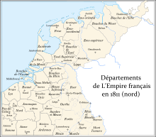
[12] During the period when the Low Countries were annexed by the French Empire and actually incorporated into France (from 1810 to 1813), Holland was divided into départements Zuyderzée, and Bouches-de-la-Meuse.
A maritime region, Holland lies on the North Sea at the mouths of the Rhine and the Meuse (Maas).
The highest point in Holland, about 55 metres (180 ft) above sea level,[16] is in the Schoorlse Duinen [nl] (Schoorl Dunes).
At present the lowest point in Holland is a polder near Rotterdam, which is about 7 metres (23 ft) below sea level.
These cities, combined with Utrecht and other smaller municipalities, effectively form a single metroplex—a conurbation called Randstad.
Population pressures are enormous, property values are high, and new housing is constantly under development on the edges of the built-up areas.
The western coastline shifted up to 30 kilometres (19 miles) to the east and storm surges regularly broke through the row of coastal dunes.
The main rivers, the Rhine and the Meuse (Maas), flooded regularly and changed course repeatedly and dramatically.
Behind the dunes on the coast of the Netherlands a high peat plateau had grown, forming a natural protection against the sea.
However, the drainage resulted in extreme soil shrinkage, lowering the surface of the land by up to 15 metres (49 feet).
From the Frisian side the sea even flooded the area to the east, gradually hollowing Holland out from behind and forming the Zuiderzee (the present IJsselmeer).
This inland sea threatened to link up with the "drowned lands" of Zealand in the south, reducing Holland to a series of narrow dune barrier islands in front of a lagoon.
The counts and large monasteries took the lead in these efforts, building the first heavy emergency dikes to bolster critical points.
They eventually constructed an extensive dike system that covered the coastline and the polders, thus protecting the land from further incursions by the sea.
Starting around the 16th century, they took the offensive and began land reclamation projects, converting lakes, marshy areas and adjoining mudflats into polders.
These stereotypes were deliberately created in the late 19th century by official "Holland Promotion" to attract tourists.
[24] Some people, especially in the area north of Amsterdam, still speak the original dialect of the county, Hollandic.