Water in California
[5] Overdrafting of groundwater—pumping more than can naturally replenish—is a pressing concern, particularly in the Central Valley, where unsustainable extraction rates lead to both a severe decline in aquifer levels and land subsidence.
Studies reveal that depletion rates in the Central Valley significantly exceed natural recharge, which endangers long-term water availability.
Satellite measurements found that in just the combined Sacramento and San Joaquin River basins, including the Central Valley, overdrafting between 2011 and 2014 was 12,000,000 acre-feet (15 km3) of water per year.
[13][14] The Sierra Nevada snowpack feeds Central Valley river systems and is a critical source of water in the state's long dry season when little if any precipitation falls.
There have been proposals to create additional inter-basin transfers from North Coast rivers to increase water supplies in the rest of California, but these projects have been rejected due to presumed environmental harm.
Precipitation falling as snow in the Sierra and other mountain ranges feeds the network of reservoirs and surface water sources that supply the state; a low rainfall or light snowfall year can result in drought.
Rivers in northern and coastal California are mainly rain fed, peaking from January to April and falling to very low levels between June and November.
[20] In addition, climate change has impacted California's precipitation patterns in recent years with effects including more rapid snowmelt, more frequent heatwaves, and drier conditions across the state.
[47] After Folsom, a city of 72,000 east of Sacramento, installed meters in 2011 and adopted tiered rates that charge more for people who consume the most water, per-capita use started falling steadily.
[47] In response to the severe California drought, in April 2015, Governor Jerry Brown issued an executive order mandating statewide reductions in water use.
The contractors pay for SWP's major operating costs and have gradually reduced the $1.75 billion bond debt that supplied funds for initial construction.
Pressure from other Colorado river states caused the Secretary of the Interior to order California to show progress towards decreasing its dependency on the excess 0.8 million acre-feet (0.99 km3), or face cuts.
To restore Mono Lake, correct air-quality law violations, and rewater portions of the Owens River, Los Angeles has begun to reduce its dependence on Eastern Sierra Nevada water.
[64] The East Bay Municipal Utility District (EBMUD) serves 35 communities in Alameda and Contra Costa Counties, including Berkeley and Oakland.
Certain municipalities north of San Francisco Bay, including Santa Rosa and Petaluma, are served by the Sonoma County Water Agency.
The evaluations and assessments performed for the updates help identify effective actions and policies for meeting California's resource management objectives in the near term and for several decades to come.
[68] The approach involves: interest based dialog and exchange among teams, committees and the public to develop work products; multiple opportunities for review by different audiences; and integration and reconciliation of feedback from a variety of perspectives.
Fundamental to that integrated approach is better alignment in the management of data, planning, policy-making, and regulation across local, State, tribal, and federal governments.
[72] The U.S. Geological Survey analyzed the results of a 2002 study of 10 streams in California and discovered that the Sacramento River had the highest traces of acetaminophen, cholesterol and birth control hormones of any water source in the nation.
[76][77] Under the doctrine, pueblos organized under the laws of Mexico or Spain have a water right to the yield of all streams and rivers flowing through the city and the groundwater aquifers lying below.
[1] The English focus on landownership differs sharply from the "first in time, first in right" approach 49ers, who were generally trespassing on federal land, developed to wash hills into rivers.
[85] In Lux v. Haggin (1886) the California Supreme Court resolved the conflict by finding that riparian water rights are superior even to older prior appropriations.
'"[89] Beginning in 1914, a statutory scheme has provided the exclusive method of acquiring appropriation rights through the California State Water Resources Control Board.
[90] The modern system of prior appropriation water rights followed by California is characterized by five principles: Beneficial use is defined as agricultural, industrial, or urban use.
[105] The bond-financing, which has been contentiously debated by the legislature and Governor Jerry Brown for the past few years, was said to improve the water quality, supply and infrastructure, if passed by voters.
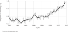
[106] The burning of fossil fuels, which has been occurring at an unprecedented rate since the Industrial Revolution in the 1950s, has increased the concentration of greenhouse gases, particularly carbon dioxide and methane, in the atmosphere.
Although California has always had extreme daily, monthly, and annual variations in rainfall, the state's precipitation patterns have become increasingly variable over time, trending towards a drier climate as a result of global warming.
By the end of the century, the California Department of Water Resources predicts that the Sierra Nevada snowpack, the state's primary freshwater source,[122] will decrease by 48-65% from its April 1 average.
California's Fourth Climate Change Assessment found that water storage in the state's two largest reservoirs, Shasta and Oroville, will decrease by one third under current management systems.
[125] Most of the documents focus on the water history from the first half of the 20th century, but there are additional, more recent publications included, which have been donated by Claremont Graduate University Professor Merrill Goodall.