Water supply and sanitation in Gibraltar
Water supply and sanitation in Gibraltar have been major concerns for its inhabitants throughout its history, from medieval times to the present day.
Gibraltar's water supply was formerly provided by a combination of an aqueduct, wells, and the use of cisterns, barrels and earthenware pots to capture rainwater.
This became increasingly inadequate as Gibraltar's population grew in the 18th and 19th centuries; the settlement was a breeding ground for lethal diseases such as cholera and yellow fever, which killed thousands of its inhabitants and members of the British garrison in repeated outbreaks.
In the late 19th century, a Sanitary Commission instigated major improvements which saw the introduction of large-scale desalination and the use of giant water catchments covering over 2.5 million square feet (nearly 250,000 m2).
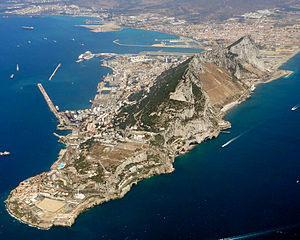
Gibraltar was uninhabited during ancient times due in part to a lack of easily accessible water to support a permanent population,[3] but in the 11th century the Moors established a fortified stronghold there in response to military threats from the Christian kingdoms of Aragon and Castile.
[4] The Moors obtained water through roof catchment of rainfall, shallow wells in the Quaternary sands to the west of the Rock of Gibraltar, and storing local surface runoff in cisterns.
A 17th-century Spanish writer, Alonso Hernández del Portillo, asserts that "the city contained many tides and fountains of very sweet and healthy water" and that "fountains of fresh water could be seen spouting out of the sea near the foot of the Rock", possibly referring to a spring at a fault called the Orillon (at the site of the later Orillon Batteries) in the north-west face of the Rock.
By the mid-19th century, however, the British writer Frederick Sayer was reporting that "there are no springs of pure fresh water"; the supplies from the few shallow wells that did exist would have been brackish at best.
The large numbers of water containers standing open across Gibraltar provided an ideal breeding habitat for mosquitoes.
From 1804, Gibraltar suffered five outbreaks of yellow fever; in the first and most devastating, the death toll amounted to 5,733 people out of a total of around 18,000, representing 32 per cent of the population.
Because the outfalls were so short, however, the sewage simply washed back up onto the shoreline and resulted in the seafront being coated in a slick of effluent.
At the same time, the military establishment came to better appreciate the importance of soldiers' living conditions after the experiences of the Crimean War, in which far more died of disease than in battle.
[17] A Parliamentary Commission on Barrack and Hospital Improvements was established in 1862 to inquire into the sanitary conditions in Gibraltar and other British Mediterranean possessions.
[12] Its conclusions were scathing; there had been no investment in the public water infrastructure in Gibraltar for 150 years, forcing the civilian population to rely entirely on their own resources and ingenuity.
The findings led to the old Spanish aqueduct and wells being closed down permanently as it was realised that they posed a severe hazard to public health.
[12] It sought to increase the amount of rainwater captured by passing Gibraltar's first Public Health Ordinance in 1869, which ordered that all new dwellings should have underground tanks.
[8] Borings were carried out on the isthmus between Gibraltar and Spain in an unsuccessful attempt to find potable groundwater, but led to an improved supply of brackish water useful for sanitary purposes.
This had been proposed as far back as 1869, when it was envisaged that condensers would be used to produce 122 cubic metres (4,300 cu ft) of pure water per day from seawater.
The idea was initially rejected due to the high cost but by the mid-1880s concern was growing that Gibraltar's water supply would be inadequate in the event of a new siege.
[21] The search for new supplies of water led engineers at the turn of the century to exploit the open expanses of the Upper Rock, where catchments were constructed by clearing vegetation and sealing fissures with cement or grout.
[1] Such catchments were primarily used by the military to provide water to the otherwise hard-to-supply batteries and outposts that existed in numerous places around the Upper Rock.
In 1903, the city's Chief Engineer came up with a plan to apply the same principle on a massive scale on the Great Gibraltar Sand Dune along the precipitous east side of the Rock in the Sandy Bay area.
[1] The water ran off into channels at the foot of the catchments, about 100 metres (330 ft) above the sea, and flowed through a tunnel to reservoirs on the west side of the Rock.
Despite their striking appearance, the catchments did not produce a great deal of water – about 60,000 cubic metres (2,100,000 cu ft) in a rainy year.
For the return journey, the water is pumped to the Moorish Castle reservoir in the upper part of the town before being distributed around the peninsula.
[27] The salt water system is divided into two sectors, serving the north and the south of the peninsula respectively, with two separate pumping stations at sea level.