Snowdon
The cliff faces on Snowdon, including Clogwyn Du'r Arddu, are significant for rock climbing, and the mountain was used by Edmund Hillary in training for the 1953 ascent of Mount Everest.
The mountain, alongside Ben Nevis in Scotland and Scafell Pike in England, is climbed as part of the National Three Peaks Challenge.
[6] The name "Snowdon" is first recorded in 1095 as Snawdune, and is derived from the Old English elements snaw and dun, meaning "snow hill".
The element gwyddfa in this context means 'height, promontory', and also appears in the Welsh name for the town of Mold, Yr Wyddgrug.
[10][11] The mountain is also linked to other figures from Arthurian legend, a legendary Afanc (water monster) and the Tylwyth Teg (fairies).
[13][14] In November 2022, national park authority announced they are to refer to the mountain by its Welsh name Yr Wyddfa, not Snowdon.
[15] Following a two-year transition period, in November 2024, the authority announced the name would be kept following its success in gaining support and adoption by businesses and media.
It was long believed to be the tallest mountain on the island of Great Britain until measurements taken in the 18th century confirmed that Ben Nevis and several other Scottish peaks were taller.
[28] The environment of Snowdon, particularly its rare plants, has led to the designation of much of the eastern part of the massif as a national nature reserve.
[36] A number of lakes are found in the various cwms of the Snowdon range: Other lakes include: Llyn Du'r Arddu below Clogwyn Du'r Arddu, at a height of 1,901 feet (579 m), 5 acres (2.0 ha); Llyn Teyrn near Pen-y-pass, at a height of 1,237 feet (377 m), 5 acres (2.0 ha); and several smaller pools.
In winter conditions, all these routes become significantly more dangerous and the Llanberis Mountain Rescue Team state that "additional skills, equipment and knowledge are required".
[49] In 2021, John Harold, the director of the Snowdonia Society, reported that the number of visitors ascending Snowdon was exceeding capacity.
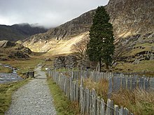
[50] The Snowdon Massif includes a number of cliffs, and holds an important place in the history of rock climbing in the United Kingdom.
[7] However, the 18th-century Welsh historian Thomas Pennant mentions a "triumphal fair upon this our chief of mountains" following Edward I's conquest of Wales in 1284, which could indicate the possibility of earlier ascents.
[29] It then reaches Plas Cwmllan, formerly the home of the quarry manager for the South Snowdon Slate Works beyond, and later used for target practice by commandos during the Second World War.
[29] From the slate quarries, the Watkin Path veers to the north-east to reach Bwlch Ciliau, the col between Snowdon and Y Lliwedd, which is marked by a large orange-brown cairn.
The Miners' Track (Welsh: Llwybr y Mwynwyr) begins at the car park at Pen-y-Pass, at an elevation of around 360 m (1,180 ft), and has the shallowest overall gradient.
Another possible explanation is that the path was named after the nearby Pen y Gwryd Hotel, popular amongst the early mountain walkers.Length: 5.0 km (3.1 mi).
The traverse of Crib Goch has been described as "one of the finest ridge walks in Britain",[45] and forms part of the Snowdon Horseshoe, a circuit of the peaks surrounding Cwm Dyli.
After the Crib Goch ridge, it descends slightly to Bwlch Coch, then ascends to the peak of Garnedd Ugain (1,065 m or 3,494 ft), before dropping to join the Llanberis path.
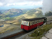
[62] It is the only public rack and pinion railway in the United Kingdom,[62][63] and after more than 100 years of operation it remains a popular tourist attraction, carrying more than 130,000 passengers annually.
The railway was constructed between December 1894, when the first sod was cut by Enid Assheton-Smith (after whom locomotive No.2 was named), and February 1896, at a total cost of £63,800 (equivalent to £9,325,000 as of 2023).
[66] When the Snowdon Mountain Railway was opened in 1896, the company strove to get an alcohol licence for its own proposed new hotel, but being unable to, took over both summit huts by 1898.
[66] During the 1930s, many complaints were received about the state of the facilities at the summit and in 1934/5 a new station building was erected in two phases; the upstairs accommodation was completed in 1937.
The new RIBA Award-winning[69] £8.4 million visitor centre, Hafod Eryri, designed by Ray Hole Architects in conjunction with Arup and built by Carillion, was officially opened on 12 June 2009[70] by First Minister Rhodri Morgan.
[71] The Welsh National Poet, Gwyn Thomas, composed a new couplet for the new building, displayed at its entrance and on the windows, which reads "Copa'r Wyddfa: yr ydych chwi, yma, Yn nes at y nefoedd / The summit of Snowdon: You are, here, nearer to Heaven".
[75] The Baron Hill Estate land consists of the farm of Gwastadannas, which includes the Snowdon Horseshoe, Glaslyn, Llyn Llydaw and the northern end of Nant Gwynant.
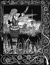
[39][45] Merlin is supposed to have hidden the golden throne of Britain among the cliffs north of Crib y Ddysgl when the Saxons invaded.
[77] Glaslyn was also the final resting place of a water monster, known as an afanc (also the Welsh word for beaver), which had plagued the people of the Conwy valley.
[84] In April 2021 a motion was put forward by Gwynedd Councillor John Pughe Roberts for Snowdon to be called by its Welsh name Yr Wyddfa in all official use, and for Snowdonia to similarly be known only as Eryri.


A rock climbing site

Legend
· grey: ridges
· red lines: paths
· orange lines: roads
· dotted grey line: Snowdon Mountain Railway