San Salvador Island
This historical importance, the island's tropical beaches, and its proximity to the United States have made tourism central to the local economy.
Columbus recorded the natives' name for the place as Guanaham,[3] now considered to be a mistranscription of Taíno Guanahaní, meaning "Small Land in the Upper Waters".
[4] San Salvador Island sits on its own isolated carbonate platform surrounded by a narrow shelf that reaches a depth of up to 40 meters (130 ft).
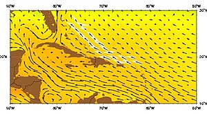
The Antilles Current originates south of the Bahamas, Puerto Rico, and Cuba and moves northward where it merges with the Gulf Stream.
In contrast, the eastern coast of San Salvador is windward and completely exposed to the rest of the Atlantic Ocean and is not protected by any other geological formations.
[11] Christopher Columbus's voyages west were sponsored by Spain in the hopes that he would reach China and the East Indies, circumventing both Turkish and Portuguese control of the eastern and southern routes of the lucrative spice trade.
[12] Letters from Columbus to the Spanish monarchs Isabella I of Castile and Ferdinand II of Aragon record that the first island sighted during his first voyage was known to its Lucayan inhabitants as Guanahaní and that he renamed it San Salvador in thanks to God.
[3][13] Arriving on 12 October 1492, he described the Lucayans as "sweet and gentle",[14] "naked as they were born",[15] possessed of "neither iron, nor steel, nor arms, nor... competent to use them",[16] "timid to a surprising degree",[16] and—combined with the other islands he visited—would enable to him to deliver to Spain "slaves, as many of these idolators as their Highnesses shall command to be shipped".
[17] Earlier in the same letter, Columbus had explained that the Lucayans were not idolators[18] but—as chattel slavery had largely disappeared from Europe during the High Middle Ages and Early Renaissance—its revival under Nicholas V's 1452 Dum Diversas... and similar bulls were dependent on the idolatrous status of the enslaved.
In the 19th century, it was usually thought to be Cat Island[23] but arguments from Juan Bautista Muñoz;[24] Captain Alexander B. Becher,[25] a hydrographer in the Royal Navy; Rear Adm. Joseph B. Murdock of the U.S. Navy;[26] Richard Henry Major,[27] map custodian of the British Museum; the geographer Clements Markham;[28] the naval historian Samuel E. Morison; and the Benedictine priest Chrysostom Schreiner eventually led to the island's 1926 renaming.
[23] More recently, the National Geographic Society, Keith Pickering,[29] and others have argued for alternative locations, including Samana Cay.
[32] More than 1,000 students and researchers work from the station every year as a base of operations for studying tropical marine geology, biology, and archeology.
The island is home to many shallow-water coral reefs, where snorkellers can observe hundreds of fish species without the use of scuba equipment.