Wayanad district
Wayanad is famous for its role in the Cotiote War, where Pazhassi Raja with the help of the Kurichya tribe in association with Hindus and Muslims of the Malabar region launched a revolt against the British.
The edicts found in the caves of Ambukuthi Mala are evidence that occupation dates from the beginning of the New Age Civilisation.
The most famous king of Ezhimala was Nannan, whose kingdom extended up to Gudalur, Nilgiris and northern parts of Coimbatore.
It is said that Nannan took refuge in the Wayanad hills in the 5th century CE when he was lost to Cheras, just before his death in battle, according to the Sangam works.
[30] The Kolathiri Dominion emerged into independent 10 principalities i.e., Kadathanadu (Vadakara), Randathara or Poyanad (Dharmadom), Kottayam (Thalassery), Nileshwaram, Iruvazhinadu (Panoor), Kurumbranad etc., under separate royal chieftains due to the outcome of internal dissensions.
[15][31] The Nileshwaram dynasty on the northernmost part of Kolathiri dominion, were relatives to both Kolathunadu as well as Zamorin of Calicut, in the early medieval period.
In the 10th century CE, the region comprised erstwhile Taluks of Kottayam, Wayanad and Gudallur was called Puraikizhanad and its feudal lord Puraikizhars.
The Thirunelly inscriptions refer to the division of Puraikizhar family into two branches viz., Elder (Muthukur) and Younger (Elamkur) in the beginning of the 11th century.
It was divided into three branches i.e., Eastern, Western and Southern under separate dignitaries known as Mootha, Elaya and Munnarkur Rajas.
[15] Thamarassery pass which connects Wayanad with the city of Kozhikode was laid in the 18th century by Tipu Sultan, the ruler of Mysore.
In 930 AD, emperor Erayappa of Ganga dynasty led his troops to south west of Mysore and after conquering, called it Bayalnad meaning the land of swamps.
Historian Sanu Kainikara states that with the end of the Sangam period, the 4th and 5th centuries brought trouble for the Cheras (who ruled entire Kerala and Kanyakumari District and adjoining areas), in that they lost control over some parts of Kerala which included Wayanad District due to the growing Kadamba power and superiority.
At the foot of the Edakal Male (hill) caves, Kannada inscriptions belonging to Canarese chieftain Vishnu Varma of Kutumbiya (Kudumbiya) clan of Mysore dating to c. 5th century CE were discovered which read – Palapulitaanamtakaari (or Pala pulinânam ta-kâri), Sri Vishnu Varma Kutumbiya Kulavardhanasya li..it..a.. As per Hultzch, a Chennai epigraphist, it speaks of the glorious descendant of Kutumbiya clan, Kannada chieftain, Vishnu Varma, as one who killed many tigers.
[36][37][38] The inscriptions of the Badami Chalukyas under their founding emperor Pulakeshin I (reign c. 540-567 CE), claim to have defeated the Cheras and the Ezhil Malai rulers, which could be a Pandya dynasty reference, and also annexed the entire Malabar region to their empire.
The Pandya, Chera and Chola powers strategised and combinedly attacked the Chalukyas as an alliance in order to avoid repeated reversals.
In 930 CE, emperor Erayappa of Ganga dynasty led his troops to south west of Mysore and after conquering, called it Bayalnad meaning the land of swamps.
An inscription discovered from a Jain Basti at Varadur near Panamaram dated to Saka era 1606 which is 1684 CE, shows that Jainism was still very powerful even in the 17th century.
The inscription which was noticed by noted epigraphist and historian M. R. Raghava Varriar, has reference about the earliest Jain settlements and temples in Wayanad.
The Kannada inscription dated Sakavarsha 1606 (i.e., 1684 CE) Rakthakshi Samvatsara Jeshtabahula Shukravara reads:Karkala aremane basthiya bommarasanu mommaga lalithappanu devapooje chinna belli thamra kanchu upakaranagalu madisi kotta bibara.
The Jain Chaithyalayas or temples referred in the inscription are Arepathra, Bennegodu, Palagondu, Hanneradubeedhi, Puthangadi (Muthangadi) and Hosangadi.
Initially the British had to suffer local resistance against their rule under the leadership of Kerala Varma Pazhassi Raja, who had popular support in Thalassery-Wayanad region.
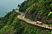
The British authorities opened up the plateau to the cultivation of tea and other cash crops by constructing roads across the dangerous slopes of Wayanad, to Kozhikode and Thalassery.
Settlers emigrated from all parts of Kerala and the fecund lands proved a veritable goldmine with incredible yields of cash crops.
The British authorities opened up the plateau to cultivation of tea and other cash crops by constructing roads across the dangerous slopes of Wayanad, to Kozhikode and Thalassery.
Settlers emigrated from all parts of Kerala and the fecund lands proved a veritable goldmine with incredible yields of cash crops.
[60] Wayanad district stands on the southern tip of the Deccan plateau and includes part of the Western Ghats.
Quite a large area of the district is covered by forest but the continued and indiscriminate exploitation of the natural resources point towards an imminent[61] environmental crisis.
The dam is ideally placed in the foothills of Banasura hills, which got its name from 'Banasura', the son of King Mahabali, the famous ruler of Kerala.
[72] The entire Wayanad plateau and all the hilly regions above the plains (above 500m MSL altitude) above the Western Ghats fell under the Kannada speaking area as per the linguistic survey and history by Colonel Mark Wilks.
[80] Paniyan: A patrilineal slave tribe community until the 1976 Bonded Labour (Abolition) Act,[81] distributed in Wayanad, Kannur, Kozhikode and Malappuram.