Waynesville, North Carolina
Waynesville is located about 30 miles (50 km) southwest of Asheville between the Great Smoky and Blue Ridge Mountains.
He donated land for the courthouse, jail, and public square, and named the town after his former commander in the war, General "Mad" Anthony Wayne.
On May 6, 1865, Union Colonel William C. Bartlett's 2nd North Carolina (Federal) Mounted Infantry were attacked at White Sulphur Springs (east of Waynesville) by a detachment of rebels from Thomas' Legion of Highlanders, who had been summoned by locals.
East of the Mississippi, Thomas' Legion fired "The Last Shot" of the Civil War in White Sulphur Springs, North Carolina.
Early during the Shenandoah Valley Campaigns of 1864, but had been sent back to their native North Carolina mountains to engage in guerrilla warfare against the remaining Union forces.
The disoriented Union soldiers retreated into Waynesville, and on the evening of May 6 remaining elements of Thomas' Legion surrounded the town.
The soldiers lit numerous bonfires on the ridges above the town and engaged in war chants in an effort to intimidate the Federals.
The following day the Confederate commanders Gen. James Green Martin and Col. William Holland Thomas (for whom the Legion was named) negotiated a surrender.
These commanders had been made aware that Generals Robert E. Lee and Joseph E. Johnston had already surrendered and that continued hostilities would prove pointless.
The agricultural, lumber and tourism industries in Waynesville and Haywood County began to thrive as access to the west was opened up.
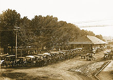
The area of Waynesville located along Richland Creek, northwest and downhill from Main Street, was where the railroad tracks were laid.
Downtown and the nearby Frog Level commercial centers of Waynesville continued to be the central focus for social life, transportation, and wholesale and retail businesses through the 1940s.
Waynesville is located southwest of the center of Haywood County in the valley of Richland Creek, a tributary of the Pigeon River.
Waynesville's water supply is located south of the town, with a watershed that covers an area of 8,400 acres (34 km2) of town-owned land on the headwaters of Allens Creek.