Weather of 2013
The 2013 extreme weather events included several all-time temperature records in Northern and Southern Hemisphere.
On March 24, 2014, the secretary-general of the World Meteorological Organization Michel Jarraud announced that "many of the extreme events of 2013 were consistent with what we would expect as a result of human-induced climate change".
In Northern Hemisphere the weather pattern repeatedly directed cold Arctic air southward, leaving Greenland and northeastern Canada much warmer than average for March.
[9] Throughout March the west Atlantic winds, which normally kept the winters in Europe relatively mild, have been blowing chiefly from the northeast, bringing in cold Arctic air.
[10] In late March, the Arctic oscillation index dropped to -5.6 and much of Northern Hemisphere experienced particularly low temperatures.
[7] The British Met Office described the cold temperatures as part of a larger-scale weather pattern in the Northern Hemisphere, associated with the negative phase of the North Atlantic Oscillation.
[11] Due to expected low temperatures overnight on February 16 and 17, an extreme cold weather alert was issued in Toronto.
On February 16 Environment Canada also issued a weather statement for York, Durham, Peel and Halton areas, warning of intensifying flurries.
The storm formed from a deep upper level trough which became a cut-off low, the event was named "Achilles" by the Weather Channel.
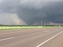
The October 2013 North American storm complex was a blizzard and tornado outbreak that affected the Northwest, Rockies, and much of the Midwest.
The storm system also included thunderstorms that brought iced precipitation, significant rain and over half a dozen tornadoes to Nebraska and Iowa.
[34][35] During March a cold easterly flow across northern Europe from Russia brought intense snowfalls across the continent as it met moisture filled air masses from Ukraine to Ireland.
Stopped on their annual way to the north by the cold weather, thousands of European golden plovers occupied the fields of central Moravia and southeast Bohemia.
The cold wave had very sunny and dry weather for over a month-long period and brought the lowest temperatures for the 2012-13 winter season.
[38] Northern France was hit by heavy snow beginning on March 11, with Météo-France warning of "dangerous weather of an exceptional intensity".
[39] French Prime Minister Jean-Marc Ayrault activated a crisis committee to coordinate government efforts to "guarantee security and movement of the country's citizens."
[39] The storm also hit the Channel Islands, producing 8-foot high drifts on Guernsey with blizzards described as the worst since 1979 according to the Jersey Met Office.
Heavy snow fell on the 12th Lethal cold has been recorded in Pale di San Martino of −49.6 °C (−57.3 °F) on 10 Feb 2013.
[45] The northern Norwegian region of Nordland saw unusually heavy snowfall, with late March seeing falls in excess of 1 metre deep.
[46] Many places in the south mountain area like Geilo, Haukeli and Hovden have their coldest average temperature in March on record.
[52] The government established a weather crisis center under direct supervision of Prime Minister Mykola Azarov.
With the state of emergency declared the military used armoured personnel carriers to drag buses out of snow drifts.
The heat returned at the beginning of August with Heathrow recording 34.1 °C (93.4 °F) On December 13 a cold snap led to snow in such cities as Cairo, Alexandria and Madinaty for the first time in 112 years.
[58] The IFRC's Disaster Relief Emergency Fund donated 57,100 Swiss francs to support the Indian Red Cross Society in delivering immediate assistance to about 10,000 people.
[3] In Uttar Pradesh and Bihar the cold wave dropped the mercury to as low as −1 °C (30 °F) which forced closure of all schools up to grade 12 until January 12.
Rising temperatures led to heat health warnings being issued for Southern England and the Midlands in the UK's first prolonged heatwave since 2006 on 17 July.
Epidemiological statisticians at the London School of Hygiene & Tropical Medicine using models developed in 2011 estimated the heatwave in England and Wales would have led to the premature deaths of 650 people.
[73] In July a heat wave struck China with alerts covering nine provinces, including Anhui, Jiangsu, Hunan, Hubei, Shanghai and Chongqing.
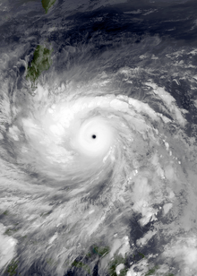
[75][76][77] The strongest and deadliest tropical cyclone of the year was Typhoon Haiyan, which attained a minimum barometric pressure of 895 hPa (26.43 inHg), along with sustained 10 minute winds of 230 km/h (145 mph).
[78][79] The costliest tropical cyclone of the year was Hurricane Manuel, which was responsible for at least $4.2 billion worth of damages in Mexico.