Weinsberg
Weinsberg lies in the eastern Heilbronn district in the northeast part of Baden-Wuerttemberg, between the Neckar in the west and the Löwenstein mountains in the east.
The small river Sulm rises from the Löwenstein mountains and flows into the Neckar after approximately 20 km (12 mi).
The Sulm valley in the north of the Schemelsberg becomes dominated by the A 6, which meets the A 81 by the Weinsberg interchange in the north-east of the town.
The highest point lies on the northern slope of the Reisberg at the southeast boundary border to Heilbronn with 338 m elevation.
[3] Weinsberg is situated on the edge of a Keuper area of the Löwenstein mountains, whose foothills extend until Neckarsulm and Öhringen.
The hole being left by the gypsum dismantling in the mountain was filled up again in the 1950s and converted into vineyards of the local viticulture school.
[4] By the incorporations the form of the communal land can be compared with an irregular (Greek) cross, whereby Weinsberg represents the short west and the thickened south bar.
In 1957 as well as 1988-2004 the land use distributed itself as follows: (Area specifications in ha, source 1957:;[5] 1988–2004:[6]): The settlement surface increases continuously, since Weinsberg still proves construction sites.
Beside 426 ha forest on the communal land of Weinsberg and its localities the city also possesses 141 ha forest on the communal land of Gemmingen, which was acquired on 29 July 1936, as reconciliation for Weinsberg's area deliveries to the state for military purposes (extension of Heilbronn's drilling place on the Waldheide).
Outside of the closed land development are the places Weißenhof (with clinical center), Rappenhof and Stöcklesberg belonging to Weinsberg, without it dealing thereby with own localities.
Gone off no longer existing places on Weinsberg's communal land are Bodelshofen, Burkhardswiesen (or Burchardeswiesen), Holßhofen, In dem Gründe, Lyndach, Uff the Wier and Wolfshöfle.
Around 500 AD, the Alamanni were displaced by the Franks, who settled on Weinsberg's communal land between Erlenbach and Gellmersbach in the 7th century.
In the area of today's Weinsberg several medieval settlements (Bodelshofen, Burchardeswiesen, Lyndach) were established, continuing even after the town foundation, but finally given up.
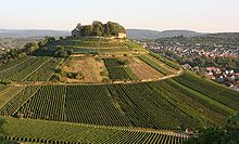
Presumably around 1000, the Weinsberg castle was established on a mountain at the trade route running from Heilbronn to Schwäbisch Hall.
Finally it had to surrender on December 21, 1140, since the army of Welf VI to release the castle had been defeated by the Staufers in a battle.
According to the report of the Chronica regia Coloniensis, the women of the castle were granted free departure and allowed to take what they could carry on their backs.
In 1241 the town was first mentioned in one Staufish income list, where Weinsberg ranked at 29 equal with Donauwörth, Wiesbaden, Offenburg and Konstanz.
In the area between these linking walls, directly underneath the castle, there were houses for priests, ministerialis and serfs of the masters.
Presumably in 1332 Weinsberg's citizens destroyed this quarter and locked the city in the west in opposite to the castle, as documents state from 1375.
His circle of friends, all of them poets, often met at his house, giving Weinsberg the reputation of being a "Swabian Weimar".
During the Second World War, Weinsberg was the site of a prison camp (Oflag Va) for Allied officers (French and British Commonwealth).
There are informal relations with Cossebaude (now a part of Dresden) in Germany, Keyworth (Nottinghamshire) in the UK and Lake Crystal, Minnesota, in the US.
The American town of Winesburg, Ohio, was originally named after Weinsberg in the early 19th century and had the spelling changed only in 1833.
With a cultivated area of 430 ha (conditions: 2005, with districts), two thirds of it are red wine sorts, standing the town in fifth place of the viticulture municipalities in Württemberg.
Since January 19, 1957, there is also the technical school of cooper business providing courses each year to a mastership examination in this profession.
[17] Formerly the Bundesstraße 39 (Heilbronn–Schwäbisch Hall) leading in west–east direction had been running right through the town, dividing Weinsberg into a northern and southern part.
Running from Heilbronn it passes the Schemelsberg in a tunnel, then it leads around Weinsberg parallel to the A 6 and finally meets the old B 39 in the east.
Public transport is provided by tram-trains operated by the Heilbronn and Karlsruhe Stadtbahns and buses co-ordinated with it by the HNV.
Weinsberg is situated on the Hohenlohebahn rail track built from 1860 to 1862 running from Heilbronn via Öhringen to Schwäbisch Hall.


from Heilbronn's Wartberg.
Burgberg on the right.