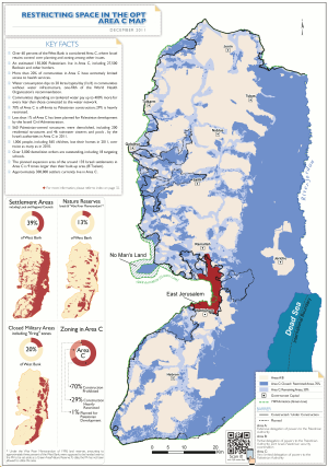
West Bank areas in the Oslo II Accord
This page is subject to the extended confirmed restriction related to the Arab-Israeli conflict.Golan Heights (1967–present) The Oslo II Accord divided the Israeli-occupied West Bank into three administrative divisions: the Palestinian enclaves as "Areas A and B" and the remainder, including Israeli settlements, as "Area C".
The Palestinian enclaves were created by a process of subtraction by allocating to Area C everything that the Israeli government considered "important", thereby consigning the vast majority of Palestinians in the West Bank to the remaining non-contiguous areas.
As of 2015, it is home to 150,000 Palestinians[3] in 532 residential areas, and roughly 400,000 Israelis[4] in 135 settlements and more than 100 unrecognized outposts.
In contrast, Areas A and B are subdivided into 165 enclaves of land that have no territorial contiguity.
[5] The Oslo II Accord stipulated that "during the first phase of redeployment" the jurisdiction over Areas A and B would be transferred to the Palestinian Council.
[6] Area A (full civil and security control by the Palestinian Authority): initially, circa 3% of the West Bank, exclusive East Jerusalem (first phase, 1995).
[2] During the second intifada, the Israel Defense Forces abolished the prohibition against entering Area A during Operation Defensive Shield in 2002 and entered the area regularly, mostly at night, conducting raids to arrest suspected militants.
[2] This area includes some 440 Palestinian villages and their surrounding lands, and no Israeli settlements.
[10] It was defined in the accord as "the populated areas delineated by a red line and shaded in yellow on attached map No.
Mrah Mia'alla Area C (full Israeli civil and security control): initially, circa 72–74% (first phase, 1995).
[12][13] Israel, however, withdrew from only 2%,[10] and during Operation Defensive Shield, it reoccupied all territory.
As of 2013, Area C formally comprised about 63% of the West Bank, including settlements, outposts and declared "state land".
[2] Including or excluding annexed East Jerusalem, no-man's land and the Palestinian part of the Dead Sea also determines the percentage.
John Kerry, U.S. Secretary of State under the Obama administration, stated that Area C "is effectively restricted for any Palestinian development, and that few building permits had been granted to Palestinian residents of the area.
[14] All Israeli settlements (except those in East Jerusalem, which was annexed to Israel) are located in Area C.[10][2] Oslo II, Article XII, for example, states: "For the purpose of this Agreement, 'the Settlements' means, in the West Bank the settlements in Area C; and in the Gaza Strip [which were later evacuated during the disengagement] ..."[6] In 1972, there were 1,000 Israeli settlers living in what is now Area C. By 1993, their population had increased to 110,000.
[18] Within 18 months from the date of inauguration, Israel would further redeploy military forces from Area C in three phases, however, without transfer of any sovereignty to the Palestinians: The Council will assume powers and responsibilities for civil affairs, as well as for public order and internal security, according to this Agreement.
After the inauguration of the Council, the Civil Administration in the West Bank will be dissolved, and the Israeli military government shall be withdrawn.
The withdrawal of the military government shall not prevent it from exercising the powers and responsibilities not transferred to the Council.
Area C, 99% of which is excluded from Palestinian use, contains most of the West Bank's natural resources and open spaces, access to which, according to the World Bank, would enable the Palestinians to halve their budget deficit and lead to an expansion of their economy by a third.
Israel, however, does not permit Palestinian construction for residential, commercial or industrial purposes.
"[21] 70 percent of the area is defined as within settler municipal boundaries, where permits for development are denied to Palestinians.
The World Bank estimates that the effect has been to cause a potential loss of $14 billion of revenue for the Palestinian economy.
[21] According to a 2013 EU report, Israeli policies have undermined the Palestinian presence in Area C, with a deterioration in basic services such as water supplies, education and shelter.
[24] As of January 2015, almost 20% of the demolition orders issued had been executed and more than 11,000 of these still outstanding, affecting an estimated 17,000 structures.
[24] During the period 1988–2014, the Israeli Civil Administration issued 6,948 demolition orders against structures in settlements located in Area C. As of January 2015, 12% of these were classified as executed, 2% were cancelled, another 2% "ready for execution" and 2% on hold due to legal proceedings.
[clarification needed][26] The most notable Palestinian settlement in the West Bank, defined by Israel as "illegal", was built in January 2013 on E1 Area East of Jerusalem.
The settlement which was named "Bab al-Shams" consisted of about 20 tents, constructed by the Popular Struggle Co-ordination Committee.
Examples he cites are the Amona settlement, overlooking Ofra, where he argues that land belonging to villagers of Deir Dibwan has been taken for redevelopment; the settlement of Itamar which he says has seized control of land and resources belonging to the Area B villages of Yanun, Awarta and Einabus; he states that settlers have seized Area B land near Esh Kodesh and Mitzpeh Ahiya east of Shilo; and he states that settlers of Ma'ale Rehav'am have built in a nature reserve established under the Wye River Memorandum.
[30] Responsibility for religious sites in the West Bank and Gaza Strip was to be transferred to the Palestinian side, gradually in the case of Area C.[31][32] The Palestinian side agreed to ensure free access to a specific list of Jewish religious sites[33] but due to the uncertain security situation the Israel Defense Forces limits visits by Jews to rare occasions.
[34] In Area C, Nabi Musa was to be under the auspices of the Palestinian side and access to al-Maghtas on the Jordan River was promised for particular religious events.