West Hills, Spokane
Just outside the municipal limit at the time, along a bend in the Spokane River, construction began on Fort George Wright in 1897 and was completed in 1899.
[5] In 1926, the Sunset Boulevard Bridge was chosen to carry U.S. Route 10, one of the first major east–west highways across the northern tier of the country.
Numerous motels and campgrounds were developed in the area just west of the bridge at the base of Sunset Hill.
The bounds of the neighborhood grew substantially in 2012 when the airport and surrounding areas were annexed into the city and named part of West Hills.
The elevated portions of the neighborhood are at the level of the surrounding Columbia Plateau which stretches to the west into Central Washington.
While on the West Plains atop the hill the area begins to open up into the Channeled Scablands with wetlands and meadows interspersed large basalt outcroppings trending in a northeast–southwest direction.
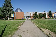
[13] In the north of the neighborhood, surrounded on three sides by a bend of the Spokane River, is the site of Fort George Wright.
The former army base is now home to Spokane Falls Community College and the Mukogawa Women's University's U.S. Campus.
Just to the south of the campuses is the River Run residential area, with both single-family and apartment homes, which has been developed over the first decades of the 21st century.
[14] A cluster of large cemeteries separates the northern portion of the neighborhood with the older residential areas in the south.
[1] The West Hills neighborhood is home to Spokane Falls Community College (SFCC), a public higher education institution, and the U.S. Campus of Mukogawa Women's University, a private university with its main campus located in Spokane's sister city of Nishinomiya, Japan.
Areas south of Indian Canyon Creek are part of the Hutton Elementary School district, located in the Rockwood neighborhood.
From just past the Airport off-ramp heading westbound, however, U.S. 2 becomes a surface street and is considered to be a principal arterial in this section.
[21] The southeastern portion of West Hills, on the shelf above the Spokane River and Latah Creek, is part of the city street grid.
Only Whistalks Way, Riverside at Government Way, and Sunset Boulevard provide surface access directly into the rest of the city.
[12][21] Non-motorized vehicles and pedestrians have access to the Fish Lake Trail, which as of 2022 has its northern terminus in West Hills one block from the major intersection of Government Way and Sunset Boulevard.