Maitland, New South Wales
Maitland (/ˈmeɪtlənd/) is a city in the Hunter Valley of New South Wales, Australia and the seat of Maitland City Council, situated on the Hunter River approximately 166 kilometres (103 mi) by road north of Sydney and 35 km (22 mi) north-west of Newcastle.
At the 2021 census it had approximately 89,597 inhabitants, spread over an area of 392 square kilometres (151 sq mi), with most of the population located in a strip along the New England Highway between the suburbs of Lochinvar and Thornton respectively.
The city centre is located on the right bank of the Hunter River, protected from moderate potential flooding by a levee.
In 1819, convict farmers were allowed to select land at Wallis Plains, the most notable of which was Molly Morgan.
[7] The oldest house (commenced 1821) in the greater Maitland LGA was called “Windermere” and also referred to the adjacent farmlands which were for agriculture and later a “boiling-down works”.
[10][11][12] In 1829, assistant surveyor George Boyle White, officially laid out a township on the site of Wallis Plains.
[13] The nearby town of Morpeth developed at the same time from the Green Hills land grant given to Lieutenant Edward Charles Close, a Peninsular War veteran.
Morpeth served as the head of navigation for larger ships (later, steamships), and goods were transhipped upriver to West Maitland on barges and smaller vessels.
[14] West Maitland was therefore the point at which goods were unloaded for, and distributed to, the prosperous riverland of the Hunter Valley.
Accordingly, there were large warehouses (some of which still exist) built, which faced onto the main High Street and backed onto the Hunter River.
[16] The first bridge to link West Maitland with what is now the suburb of Lorn was opened in 1869 and named in honour of the then Governor of New South Wales, the 4th Earl of Belmore.
The new bridge, which redirected traffic away from St Andrews Street to a new intersection at the Maitland Court House, is one of the city's three main river crossings.
[22] Flooding was described as an “annoyance” and “detrimental to the town” in the 7 April 1840 advertisement for the sale of “Windermere” where position “on a hill” was described as an appealing feature.
The volume of flood water was approximately 3,750,000 megalitres (8.2×10¹¹ imp gal) and the cost of damage, in today's currency, would have been over A$2 billion.
During the flooding in 2007, the Hunter River was expected to reach a peak of 11.3 m (37.1 ft) at Maitland's Belmore Bridge and break levee banks.
Some 4000 residents of the suburb of Lorn were evacuated before the floodwaters became stable at 10.7 m (35.1 ft) and did not inundate central Maitland.
[24] Other areas did not escape with waters inundating homes in Branxton, Louth Park and Raymond Terrace.
From 20 to 22 April 2015, heavy rainfall in the Hunter, Central Coast and Sydney regions of New South Wales resulted in flash flooding and extended power outages to over 200,000 homes.
[26] The towns of Dungog and Gillieston Heights, the homes of the four flood victims, were also badly affected, becoming isolated from other communities.
[29] The Immigrants Home was founded by Caroline Chisholm in East Maitland and was the first public building that was used to treat the sick.
[30] In April 1845 Sir George Gipps approved a grant of a site at Campbell's Hill, West Maitland opposite Boyne's Inn.
[30] The cost of the building was not to exceed £2000 and fifteen guineas would be awarded to the party furnishing the approved plan.
The Mercury, established in 1843, operates out of offices on High Street and is Australia's oldest regional newspaper.
The famous Scottish entertainer Sir Harry Lauder performed to a packed audience in Maitland Town Hall on Saturday 15 August 1925.
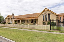
[54] Maitland has many educational facilities ranging from primary and high schools to short course vocational training operations.
These facilities provide excellent training in all fields, especially building and construction, engineering, mining, tourism and business administration.