White Pine County, Nevada
The county boasts dark skies, clean air and millions of acres of unspoiled public land.
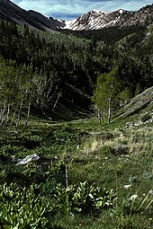
It is also home to no less than 14 federally designated wilderness areas, offering an abundance of terrain available to explore for hikers, backpackers, skiers, hunters and anglers.
The reservation has a land area of 104.99 acres (0.4249 km2) and a 2000 census official resident population of 133 people.
In the southeastern part of the county within Great Basin National Park lies 13,065 ft (3,982 m) Wheeler Peak, the tallest independent mountain within Nevada and the second-highest point within the state (the highest point being Boundary Peak).
White Pine County is home to a number of designated wilderness areas.
They were created by Congress on December 20, 2006, by the "White Pine County Conservation, Recreation, and Development Act of 2006.
White Pine County's population grew rapidly in the early part of the 20th Century in response to mining activity, and has remained relatively stable at around 9,500 residents since about 1950.
Although mining has been a major employer throughout the county's history, tourism and services related to outdoor recreation are beginning to account for a larger share of jobs in the region.
29.6% of all households were made up of individuals, and 11.5% had someone living alone who was 65 years of age or older.
As of the 2010 United States Census, there were 10,030 people, 3,707 households, and 2,344 families living in the county.
[12] In terms of ancestry, 26.9% were American, 11.3% were English, 11.2% were German, 10.4% were Irish, and 5.6% were Italian.
[16] Regional offices of the U.S. Bureau of Land Management and the U.S. Forest Service are located in Ely.