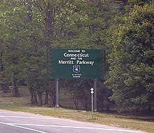
Connecticut Route 15
The unified designation was applied to these separate highways in 1948 to provide a continuous through route from New York to Massachusetts.
From there, Route 15 turns northeast, and curves through its interchange with North Street, which provides another outlet into Downtown Greenwich.
Just past its crossing of the Silvermine River, Route 15 meets the U.S. Route 7 (US 7) freeway at an incomplete interchange before it crosses over the Danbury Branch of the New Haven Line just south of the Merritt 7 station, and the Norwalk River and comes to a cloverleaf interchange with Main Avenue which provides the missing movements between the parkway and US 7.
Immediately after this interchange, the parkway crosses over Route 136 with no access and enters its longest stretch without exits, where it passes more wooded residential areas and comes into the town of Fairfield, where it meets its next interchange, five and a half miles later, at Route 58, which also has a park and ride lot, located in its southeastern corner.
The parkway turns east-northeast and enters the town of Trumbull at its interchange with Park Avenue, which provides access to the campus of Sacred Heart University just to the southwest of the road, as well as the campus of the University of Bridgeport in the adjacent city of Bridgeport.
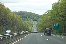
Past this interchange, the parkway runs due east to cross the Igor Sikorsky Memorial Bridge over the Housatonic River where it leaves both Stratford and Fairfield County.
At this point, the Merritt Parkway ends and Route 15 turns northeast again through the wooded residential areas of southwestern New Haven County.
The parkway crosses the Wepawaug River, where it turns northeast and enters the town of Woodbridge, passing under Route 114 without access.
[4] Route 15 continues northeast into the city of Meriden and passes entrances to the ConnDOT maintenance facilities.
The parkway continues a short distance before reaching an interchange complex on the east side of town.
First, Route 15 crosses over the I-91 freeway, where it turns north to reach a southbound exit and northbound entrance, before meeting East Main Street, which provides access to the Wesleyan University campus, where the Interstate Highway begins to run inside the median.
[4] Route 15 continues onto a four-lane arterial road concurrent with US 5, known as the Berlin Turnpike, running between Silver Lake to the west and Lamentation Mountain to the east.
The highway enters the town of Berlin and Hartford County, and briefly forms the western edge of Lamentation Mountain State Park, before heading back into commercial areas.
North of Route 9, the old alignment of the Berlin Turnpike rejoins the new road briefly, before splitting again, this time to the east.
The highway continues to its junction with the southern terminus of Route 176, which heads north towards the center of Newington.
[4] Past Route 314, US 5/Route 15 continue onto the Wilbur Cross Highway, a four-lane freeway with a jersey barrier in the middle.
[4] From here, US 5/Route 15 cross over the Connecticut River on the Charter Oak Bridge, where the routes enter the town of East Hartford.
Route 15 curves to a northbound exit and southbound entrance with Silver Lane, before the highway reaches its northern terminus and merges onto eastbound I-84 and US 6.
By 1949, the Wilbur Cross Parkway was completed and the temporary Route 15 designation was removed from the surface streets.
In addition to gas pumps and an Alltown convenience store at each plaza, they now include Dunkin' Donuts and Subway shops.