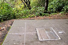
Willamette Stone
The site is near Skyline Boulevard, in the West Hills overlooking the Tualatin Valley and the Willamette River watershed.
The first marker, a red cedar stake, was placed on the site on June 4, 1851, by John B. Preston, the first Surveyor General of the Oregon Territory.
[1] Preston was appointed by President Millard Fillmore to create a system for surveying land in the territory;[2] he lost his position in 1853, and "drifted into obscurity.
"[3] The location was chosen such that the baseline would not cross the Columbia River and the meridian would lie west of Vancouver Lake.
[4] The meridian and baseline were surveyed using solar compasses by James E. Freeman of Wisconsin and William Ives of Michigan.