Winthrop Avenue
Past the colleges, 200 metres (660 ft) north of the intersection, the road becomes the boundary between Kings Park to the east, and the suburb of Nedlands to the west.
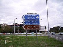
From this point north, Winthrop Avenue is also part of Tourist Drive 200, a circular route around Kings Park.
[2] Residential properties line the northbound carriageway for 350 metres (1,150 ft), until the Monash Avenue traffic light controlled intersection.
North of this intersection is the Queen Elizabeth II Medical Centre, where Sir Charles Gairdner Hospital is located.
Winthrop Avenue travels alongside the medical centre site for 700 metres (2,300 ft) until its northern terminus at Aberdare Road, at the southern edge of Shenton Park.