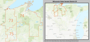
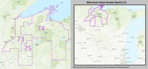
Wisconsin's 25th Senate district
[1] Located in northwest Wisconsin, where Wisconsin meets Lake Superior, the district comprises all of Ashland, Bayfield, Burnett, Douglas, Iron, Polk, Sawyer, and Washburn counties.
The district also includes the Bad River Indian reservation and the Chequamegon–Nicolet National Forest.
Previous politicians of a specific numbered district have represented a different geographic area, due to redistricting.
After the fifth (1852) session of the state legislature, the Wisconsin Senate was expanded to 25 members.
The short-lived redistricting of 1891 left the district consisting of Clark, Price, Taylor, and Wood Counties.
After a great deal of litigation, the Wisconsin Supreme Court created a redistricting map promulgated on May 14, 1964.
Previous politicians of a specific numbered district have represented a completely different geographic area, due to redistricting.