Wisconsin Highway 35
The southern terminus of WIS 35 is at the Illinois–Wisconsin border, three miles (4.8 km) north of East Dubuque, Illinois.
WIS 35 and US 61 continue to the northwest to the village of Tennyson before heading north towards the city of Lancaster.
After intersecting with the southern terminus of WIS 129, the three routes enter Lancaster as Madison Street.
The two highways continue in a generally northerly direction towards the village of Patch Grove, where they intersect with US 18.
WIS 35 runs along the Mississippi River's east banks through the cities of Lynxville and Ferryville.
WIS 35 continues north on the Great River Road while US 53 heads east on I-90 for a mile (1.6 km) to exit 4.
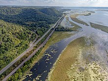
WIS 35 continues along the eastern banks of the Mississippi River, running parallel to the US 53 freeway to the east before interchanging with it just south of Holmen.
About two miles (3.2 km) west of the US 53 interchange, WIS 35 crosses the Black River into Trempealeau County.
About two miles (3.2 km) northwest of Fountain City, WIS 35 passes the entrance to Merrick State Park.
WIS 35 misses Buffalo City by about one-mile (1.6 km) to the east, along the Belvidere Ridge of West Central Wisconsin.
Continuing its route along the Mississippi, WIS 35 goes through the community of Stockholm and turns to the north along the river banks before entering Pierce County.
In Pierce County, WIS 35 goes through the small community of Maiden Rock, Warrentown and Bay City.
In downtown Prescott, WIS 35 intersects with US 10 at Cherry Street, just northeast of the confluence of the St. Croix and Mississippi rivers.
At Campbell Street North, WIS 35 turns to the northeast as US 10 continues east to start its long journey across the state of Wisconsin.
The intersection of the two highways is also the western terminus of WIS 29, one of the main arterial routes connecting the Twin Cities area with Green Bay.
WIS 35 turns to the north, about a block east of the Apple River, onto Church Hill Road.
After passing through the unincorporated town of East Farmington, WIS 35 continues on to the city of Osceola as Cascade Street.
WIS 243 is the shortest regularly-signed highway in Wisconsin, as it runs the length of Osceola Road over the St. Croix River to MN 243 in Franconia Township, Chisago County, Minnesota.
WIS 35 swings to the northeast on North Cascade Street through downtown Osceola, then out of the city.
Passing Osceola Bedrock Glades State Natural Area, WIS 35 continues north towards the village of Dresser on its way to St. Croix Falls.
Just outside the city of St. Croix Falls, WIS 35 heads east with US 8 on a limited-access expressway for about three and a half miles (5.6 km).
In St. Croix Falls township, WIS 35 turns to the north while US 8 continues east to Turtle Lake.
WIS 35/WIS 77 continues to the north, coming within 148 yards (135 m) from the Minnesota border at the mouth of the Yellow River.
Continuing north, WIS 35 passes through the unincorporated towns of Dairyland, Moose Junction, and Chaffey before entering Pattison State Park.
WIS 35 enters Superior as Tower Avenue, running north through the South End neighborhood of the city.
WIS 35 continues north into Superior, passing Richard I. Bong Airport into the downtown area.