Wisconsin Highway 42
WIS 42 follows North 14th Street to Calumet Drive, which heads out of the city in a northwesterly direction to its interchange with Interstate 43 (I-43) at exit 128 which has four roundabouts within a mile; two controlling freeway access, a retail development with Walmart and Menards at Vanguard Drive, and then CTH-Y.
Turning east, WIS 42 runs concurrently with US 151 for about a quarter mile (0.4 km) before US 151 ends at I-43.
WIS 42 then travels on Calumet Avenue into Manitowoc's business district where it intersects with US 10 twice before leaving US 10 and turning east onto Waldo Boulevard for Lake Michigan and Two Rivers.
WIS 42 continues to the north, running roughly parallel to the Lake Michigan shoreline into Kewaunee County.
WIS 42 becomes Main Street after crossing the Kewaunee River and continues north out of the city.
At its intersection with CTH-J in Forestville, WIS 42 heads directly north into Door County.
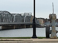
WIS 42/WIS 57 crosses over the Sturgeon Bay Ship Canal to the southeast of downtown, bypassing the old Michigan Street bridge further upstream.
CTH-HH jogs slightly north around Big Hill Park to Egg Harbor Road, where the business route turns northeast past the Door County Fairgrounds to its intersection with WIS 42/WIS 57 outside the city.
Outside of Fish Creek, WIS 42 takes an abrupt left-hand turn to follow the bluff down to Main Street and the Alexander Noble House.
WIS 42 makes an abrupt right onto Main Street and heads to the northeast past Peninsula State Park into the village of Ephraim.
In Ephraim, the road becomes Water Street as it runs along the shoreline of Eagle Harbor along Green Bay.
At Gills Rock, WIS 42 turns due east and then turns slightly to the southeast before heading due east again to its eastern terminus at the Washington Island Ferry dock at Port Des Morts Drive in unincorporated town of Northport.
A stretch of the highway just before its northern terminus near Porte des Morts is well-renowned locally due to having 15 seemingly redundant curves causing the road to meander unnecessarily.
The reasons for this winding section remain uncertain, with one theory assuming the bends were designed simply to weave around utility poles or to reduce the need for tree felling.
WIS 42's current iteration began in 1930 as a route that almost entirely paralleled Lake Michigan from Pleasant Prairie to Algoma including Milwaukee and eventually reaching Sister Bay along its current routing including Sturgeon Bay.
[9] A meteorite 14 feet (4.3 m) in circumference struck 4+1⁄2 miles (7.2 km) north of Carlsville, Wisconsin.
Highways around Manitowoc changed during September 2022, including the relocation of WIS 42 back onto its original alignment in the city and the reversion of 8th and 10th streets into two-way roads.
It starts off at an incomplete exit from WIS 42/57, and follows Green Bay Road to Madison Avenue.