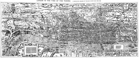
Woodcut map of London
The original map probably dated from the early 1560s, but it survives only in later and slightly modified copies.
It also bears a close resemblance to the map of London included in Georg Braun and Frans Hogenberg's Civitates Orbis Terrarum, published in Cologne and Amsterdam in 1572, although this is on a greatly reduced scale.
Stephen Powys Marks suggests that this adjustment "may be an indication of an appeal to a less sophisticated public than that which would buy the fine copper engraving".
This attribution has its roots in a claim made by Agas in 1588 to the effect that for ten years past he had been hoping to undertake a survey of London.
On the basis of this statement, the late 17th-century engraver of a copy of the map on pewter sheets associated Agas's name with it; and the attribution was then asserted more firmly by the antiquary George Vertue in 1737–8.
In 1978, the map was published in large-format atlas form by the London Topographical Society (in association with Harry Margary and Guildhall Library) as The A to Z of Elizabethan London, overprinted with street names and a basic grid, and with introductory notes by John Fisher and a comprehensive index.