Wrangell–St. Elias National Park and Preserve
Elias National Monument on December 1, 1978, by President Jimmy Carter using the Antiquities Act, pending final legislation to resolve the allotment of public lands in Alaska.
As stated in the foundation document:[7] The purpose of Wrangell-St. Elias National Park and Preserve is to maintain the natural scenic beauty of the diverse geologic, glacial, and riparian dominated landscapes, and to protect the attendant wildlife populations and their habitats; to ensure continued access for a wide range of wilderness-based recreational opportunities; to provide continued opportunities for subsistence use.Wrangell–St.
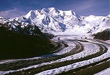
Nine of the 16 highest peaks on U.S. soil are located in the park, along with North America's largest subpolar icefield, glaciers, rivers, an active volcano, and the historic Kennecott copper mines.
[25] Air taxis provide sightseeing services and visitor transportation within the park, based in Glennallen, Chitina, Nabesna, and McCarthy.
[29] The southern part of Alaska is composed of a series of terranes that have been pushed against the North American landmass by the action of plate tectonics.
The Pacific Plate subducts under the Alaskan landmass, compressing the continental rocks and giving rise to a series of mountain ranges.
[37] The Alaskan coast reached an approximation of its modern configuration about 50 million years ago, with the complete subduction of the now-vanished Kula Plate under North America.
[38] Their growth is associated with the arrival of the Yakutat terrane, with considerable activity until about 200,000 years ago, when movement along the Denali-Totchunda and Fairweather faults began to accommodate some of the Pacific Plate's motion.
All but Mount Wrangell have been modified by glaciers to sharper, steeper relief than the gentle, rounded forms that characterize young shield volcanoes.
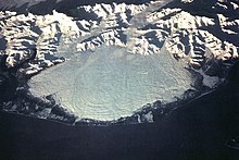
During the 1980s the summit's heat flux was sufficient to melt 100 million cubic metres (3.5×10^9 cu ft) of ice and form a small crater lake.
[48] Several hot springs or mud volcanoes in the vicinity of Mount Drum produce warm brackish water charged with carbon dioxide.
[58] A number of other sites on the southern side of the Wrangells were investigated and prospected, and some even produced small amounts of ore, but none were commercially exploited.
A permanent Russian trading post was established in 1793 by the Lebedev-Lastochkin Company at Port Etches on Hinchinbrook Island near the mouth of the Copper River.
The same year a U.S. Army party led by Lieutenant William Abercrombie attempted to explore the lower river, and found a passage to the country's interior over a glacier at the Valdez Arm.
Shortly afterwards prospectors Jack Smith and Clarence Warner are said to have noticed a green spot on a hillside at what is now Kennecott, which proved to be a rich copper lode.
[70] Reports of oil and gas seeps in the vicinity of Cape Yakutaga and Controller Bay inspired petroleum exploration on the southern margin along the Gulf of Alaska.
[73] Gruening was supported by Secretary of the Interior Harold L. Ickes, but President Franklin D. Roosevelt declined to act, noting that there was no urgency, and citing his directive that all non-defense related measures be deferred to preparations for the looming World War II.
A scaled-back park of 8,640,000 acres (3,500,000 ha) was proposed by Interior in 1973, together with a 5.5-million-acre (22,000 km2) Wrangell Mountain National Forest, getting a cold reception from both preservationists and developers.
Following this blockage and with efforts on the part of Alaska authorities to claim lands that fell within the proposed protections, President Jimmy Carter invoked the Antiquities Act to proclaim 17 Alaskan national monuments, including 10,950,000 acres (4,430,000 ha) in Wrangell–St.
Attitudes were sharply divided between white Alaskans, who were largely opposed to the park and felt that they were being forced out, and native Ahtnas, who were granted subsistence hunting rights and who expected to profit from tourism.
Incidents continued, notably involving arson at a ranger station, and relations bottomed again in 1994 when the park superintendent Karen Wade testified before Congress for increased funding in a way that was perceived to confirm residents' suspicions about the Park Service, exacerbated by commentary from local newspapers that was wrongly attributed to Wade.
[88] The state of Alaska proposed major improvements to the McCarthy Road in 1997, planning to pave it and add scenic turnouts and trailheads along its length[citation needed].
Elias and three other national and provincial parks) was declared a UNESCO World Heritage Site in 1979 for the spectacular glacier and icefield landscapes as well as for the importance of grizzly bears, caribou and Dall sheep habitat.
According to the United States Department of Agriculture, the Plant Hardiness zone at the Kennecott Visitor Center (1985 ft / 605 m) is 3a with an average annual extreme minimum temperature of -37.8 °F (-38.8 °C).
[93] As the park and preserve cover an area larger than Switzerland, extending from the Gulf of Alaska to the Alaskan interior, with altitudes that vary from sea level to 19,000 feet (5,800 m), Wrangell–St.
[96] The environment can be divided into five major categories, apart from the relatively sterile glacial and riverbed areas: lowlands, wetlands, uplands, sub-alpine and alpine.
Black spruce dominates areas of permafrost, with understories of alder, Labrador tea, willows and blueberry, with a variety of ground mosses.
The smaller mammals include the wolverine, North American beaver, Canadian lynx, porcupine, pine marten, river otters, red fox, some coyote, Arctic ground and flying squirrels, hoary marmot, weasels, ermine, snowshoe hare, several species of voles and mice, and pikas.
Other fish include eulachon, burbot, round whitefish, northern pike, Pacific lamprey, lake chub and a variety of sculpins.
The most common birds include bald eagle, willow and rock ptarmigan, Canada jays, ravens, hermit thrushes, American robins, lesser yellowlegs, wandering tattler, hairy woodpeckers and northern flickers.